
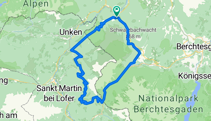
Reiteralpe mit Abstecher zur Litzlalm
A cycling route starting in Schneizlreuth, Bavaria, Germany.
Overview
About this route
Very beautiful tour, partly with some steeper ascents, excellent view at the Litzlalm.
- -:--
- Duration
- 53.7 km
- Distance
- 1,668 m
- Ascent
- 1,668 m
- Descent
- ---
- Avg. speed
- ---
- Max. altitude

Continue with Bikemap
Use, edit, or download this cycling route
You would like to ride Reiteralpe mit Abstecher zur Litzlalm or customize it for your own trip? Here is what you can do with this Bikemap route:
Free features
- Save this route as favorite or in collections
- Copy & plan your own version of this route
- Sync your route with Garmin or Wahoo
Premium features
Free trial for 3 days, or one-time payment. More about Bikemap Premium.
- Navigate this route on iOS & Android
- Export a GPX / KML file of this route
- Create your custom printout (try it for free)
- Download this route for offline navigation
Discover more Premium features.
Get Bikemap PremiumFrom our community
Other popular routes starting in Schneizlreuth
 BAUMGARTEN-VOGELSPITZ-WACHTERL
- Distance
- 22.1 km
- Ascent
- 935 m
- Descent
- 933 m
- Location
- Schneizlreuth, Bavaria, Germany
 Weissbacher Salinen Rundweg
- Distance
- 7.9 km
- Ascent
- 294 m
- Descent
- 295 m
- Location
- Schneizlreuth, Bavaria, Germany
 Rund um die Reiteralpe CLONED FROM ROUTE 322882
- Distance
- 51.7 km
- Ascent
- 1,617 m
- Descent
- 1,617 m
- Location
- Schneizlreuth, Bavaria, Germany
 Baumgarten-Moosenalm
- Distance
- 7.6 km
- Ascent
- 943 m
- Descent
- 51 m
- Location
- Schneizlreuth, Bavaria, Germany
 MTB M'N'B t20
- Distance
- 224.9 km
- Ascent
- 5,907 m
- Descent
- 5,819 m
- Location
- Schneizlreuth, Bavaria, Germany
 Rund um den Hochkönig
- Distance
- 167.8 km
- Ascent
- 1,295 m
- Descent
- 1,299 m
- Location
- Schneizlreuth, Bavaria, Germany
 Reiteralpe mit Abstecher zur Litzlalm
- Distance
- 53.7 km
- Ascent
- 1,668 m
- Descent
- 1,668 m
- Location
- Schneizlreuth, Bavaria, Germany
 Reiteralpe Hintersee 8er Runde
- Distance
- 72.8 km
- Ascent
- 2,485 m
- Descent
- 2,485 m
- Location
- Schneizlreuth, Bavaria, Germany
Open it in the app