
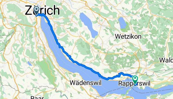
Route to Zurich
Route to Zurich
A cycling route starting in Zürich (Kreis 4) / Werd, Canton of Zurich, Switzerland.
Overview
About this route
- 2 h 11 min
- Duration
- 36.8 km
- Distance
- 338 m
- Ascent
- 352 m
- Descent
- 16.9 km/h
- Avg. speed
- 495 m
- Max. altitude
Part of
Route to Zurich
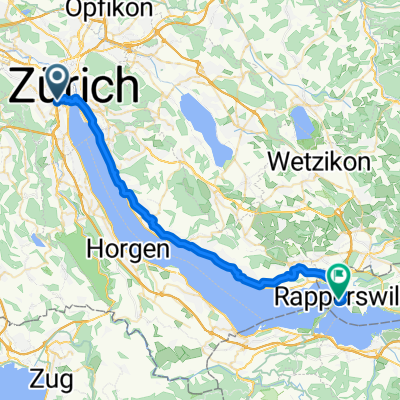
2 stages
Route quality
Waytypes & surfaces along the route
Waytypes
Quiet road
27.2 km
(74 %)
Path
5.1 km
(14 %)
Surfaces
Paved
34.6 km
(94 %)
Unpaved
0.4 km
(1 %)
Asphalt
34.6 km
(94 %)
Gravel
0.4 km
(1 %)
Undefined
1.8 km
(5 %)
Continue with Bikemap
Use, edit, or download this cycling route
You would like to ride Route to Zurich or customize it for your own trip? Here is what you can do with this Bikemap route:
Free features
- Save this route as favorite or in collections
- Copy & plan your own version of this route
- Sync your route with Garmin or Wahoo
Premium features
Free trial for 3 days, or one-time payment. More about Bikemap Premium.
- Navigate this route on iOS & Android
- Export a GPX / KML file of this route
- Create your custom printout (try it for free)
- Download this route for offline navigation
Discover more Premium features.
Get Bikemap PremiumFrom our community
Other popular routes starting in Zürich (Kreis 4) / Werd
 Route to Zurich
- Distance
- 36.8 km
- Ascent
- 338 m
- Descent
- 352 m
- Location
- Zürich (Kreis 4) / Werd, Canton of Zurich, Switzerland
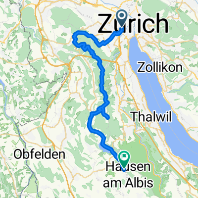 Stauffacherstrasse, Zürich nach Schöneggstrasse, Hausen am Albis
- Distance
- 30.9 km
- Ascent
- 1,082 m
- Descent
- 878 m
- Location
- Zürich (Kreis 4) / Werd, Canton of Zurich, Switzerland
 Stauffacherquai 52, Zürich to Stauffacherquai 58, Zürich
- Distance
- 5.1 km
- Ascent
- 3 m
- Descent
- 3 m
- Location
- Zürich (Kreis 4) / Werd, Canton of Zurich, Switzerland
 To Kappel am Ablis
- Distance
- 52.8 km
- Ascent
- 449 m
- Descent
- 410 m
- Location
- Zürich (Kreis 4) / Werd, Canton of Zurich, Switzerland
 nach
nach- Distance
- 34 km
- Ascent
- 700 m
- Descent
- 700 m
- Location
- Zürich (Kreis 4) / Werd, Canton of Zurich, Switzerland
 Klausen ab Zürich
- Distance
- 236.2 km
- Ascent
- 1,786 m
- Descent
- 1,786 m
- Location
- Zürich (Kreis 4) / Werd, Canton of Zurich, Switzerland
 Pragelpass
- Distance
- 175.2 km
- Ascent
- 1,767 m
- Descent
- 1,764 m
- Location
- Zürich (Kreis 4) / Werd, Canton of Zurich, Switzerland
 Langnau
- Distance
- 55.5 km
- Ascent
- 504 m
- Descent
- 494 m
- Location
- Zürich (Kreis 4) / Werd, Canton of Zurich, Switzerland
Open it in the app