
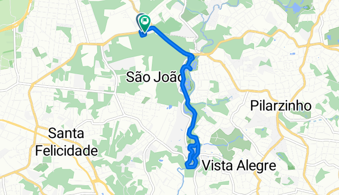
Rota recuperada
A cycling route starting in Curitiba, Paraná, Brazil.
Overview
About this route
Embark on an exhilarating 8-kilometer cycling adventure that challenges and rewards with every pedal stroke. Begin your journey at a manageable 914 meters above sea level, gradually ascending to the summit at 964 meters. As you climb, the elevation gain of 129 meters will push your limits, but the descent of 116 meters offers a thrilling payoff, keeping you energized and motivated. This route is ideal for those seeking a mix of challenge and scenic beauty, perfect for cyclists looking to explore the natural landscape while enjoying a moderate yet rewarding workout.
AI generated
- 24 min
- Duration
- 8 km
- Distance
- 129 m
- Ascent
- 116 m
- Descent
- 20.3 km/h
- Avg. speed
- 965 m
- Max. altitude

Route quality
Waytypes & surfaces along the route
Waytypes
Cycleway
6.7 km
(84 %)
Quiet road
0.7 km
(9 %)
Surfaces
Paved
4 km
(50 %)
Unpaved
0.1 km
(1 %)
Asphalt
3.9 km
(49 %)
Wood
0.1 km
(1 %)
Continue with Bikemap
Use, edit, or download this cycling route
You would like to ride Rota recuperada or customize it for your own trip? Here is what you can do with this Bikemap route:
Free features
- Save this route as favorite or in collections
- Copy & plan your own version of this route
- Sync your route with Garmin or Wahoo
Premium features
Free trial for 3 days, or one-time payment. More about Bikemap Premium.
- Navigate this route on iOS & Android
- Export a GPX / KML file of this route
- Create your custom printout (try it for free)
- Download this route for offline navigation
Discover more Premium features.
Get Bikemap PremiumFrom our community
Other popular routes starting in Curitiba
 Colombo Estrada Ribeira-Rod. da Uva- Prado
- Distance
- 45.8 km
- Ascent
- 448 m
- Descent
- 448 m
- Location
- Curitiba, Paraná, Brazil
 Turismo Rural
- Distance
- 49.7 km
- Ascent
- 424 m
- Descent
- 424 m
- Location
- Curitiba, Paraná, Brazil
 De Rua Lourenço Tuletzki a Rua Lourenço Tuletzki
- Distance
- 23.8 km
- Ascent
- 259 m
- Descent
- 264 m
- Location
- Curitiba, Paraná, Brazil
 Portao estrada bateias MTB
- Distance
- 58.5 km
- Ascent
- 559 m
- Descent
- 558 m
- Location
- Curitiba, Paraná, Brazil
 Casa - Pedágio da 277 - Casa
- Distance
- 87.3 km
- Ascent
- 754 m
- Descent
- 754 m
- Location
- Curitiba, Paraná, Brazil
 De Rua Visconde de Cairu 434 a Rua Visconde de Cairu 434
- Distance
- 8.1 km
- Ascent
- 95 m
- Descent
- 99 m
- Location
- Curitiba, Paraná, Brazil
 Centro-116
- Distance
- 37.3 km
- Ascent
- 302 m
- Descent
- 302 m
- Location
- Curitiba, Paraná, Brazil
 Rua Mateus Leme, Curitiba a Rua Mateus Leme, Curitiba
- Distance
- 12.8 km
- Ascent
- 109 m
- Descent
- 104 m
- Location
- Curitiba, Paraná, Brazil
Open it in the app