
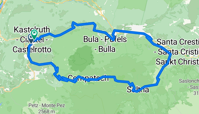
Route in Kastelruth
A cycling route starting in Kastelruth, Trentino-Alto Adige, Italy.
Overview
About this route
kastelruth seiser lm
- 2 h 53 min
- Duration
- 39 km
- Distance
- 1,616 m
- Ascent
- 1,617 m
- Descent
- 13.5 km/h
- Avg. speed
- 1,885 m
- Max. altitude

Route quality
Waytypes & surfaces along the route
Waytypes
Road
14 km
(36 %)
Quiet road
8.6 km
(22 %)
Surfaces
Paved
20.7 km
(53 %)
Unpaved
4.3 km
(11 %)
Asphalt
20.3 km
(52 %)
Loose gravel
2.3 km
(6 %)
Continue with Bikemap
Use, edit, or download this cycling route
You would like to ride Route in Kastelruth or customize it for your own trip? Here is what you can do with this Bikemap route:
Free features
- Save this route as favorite or in collections
- Copy & plan your own version of this route
- Sync your route with Garmin or Wahoo
Premium features
Free trial for 3 days, or one-time payment. More about Bikemap Premium.
- Navigate this route on iOS & Android
- Export a GPX / KML file of this route
- Create your custom printout (try it for free)
- Download this route for offline navigation
Discover more Premium features.
Get Bikemap PremiumFrom our community
Other popular routes starting in Kastelruth
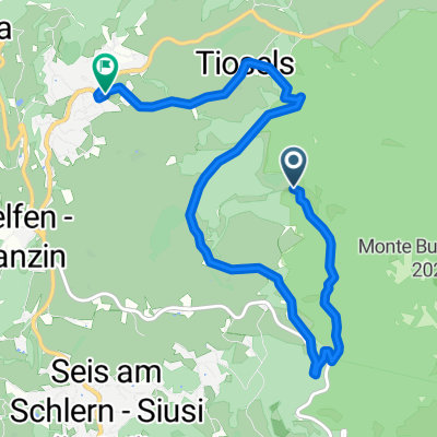
 Telfen.. St. Konstantin.. Vols.. Volser weiher.. Telfen
- Distance
- 24.1 km
- Ascent
- 664 m
- Descent
- 665 m
- Location
- Kastelruth, Trentino-Alto Adige, Italy
 Moderate Route
- Distance
- 7.9 km
- Ascent
- 59 m
- Descent
- 546 m
- Location
- Kastelruth, Trentino-Alto Adige, Italy
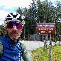 PASSO PINEI/ PAINDERSATTEL (por Castelrotto)
- Distance
- 7.4 km
- Ascent
- 423 m
- Descent
- 68 m
- Location
- Kastelruth, Trentino-Alto Adige, Italy
 Castelrotto-Cortina
- Distance
- 41 km
- Ascent
- 1,801 m
- Descent
- 1,255 m
- Location
- Kastelruth, Trentino-Alto Adige, Italy
 St.Oswald-Kastelruth-Seiser Alm-Seis-St.Oswald
- Distance
- 35.9 km
- Ascent
- 1,313 m
- Descent
- 1,281 m
- Location
- Kastelruth, Trentino-Alto Adige, Italy
 Route in Kastelruth
- Distance
- 39 km
- Ascent
- 1,616 m
- Descent
- 1,617 m
- Location
- Kastelruth, Trentino-Alto Adige, Italy
 seiser alm
- Distance
- 22.2 km
- Ascent
- 774 m
- Descent
- 778 m
- Location
- Kastelruth, Trentino-Alto Adige, Italy
 11.7. - Kastelruth - Weisslahnbad
- Distance
- 51.1 km
- Ascent
- 1,088 m
- Descent
- 1,089 m
- Location
- Kastelruth, Trentino-Alto Adige, Italy
Open it in the app