
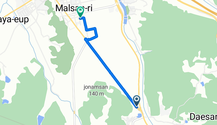
함안군에서 함안군까지
A cycling route starting in Naesŏ, Gyeongsangnam-do, South Korea.
Overview
About this route
- 21 min
- Duration
- 3.3 km
- Distance
- 9 m
- Ascent
- 24 m
- Descent
- 9.5 km/h
- Avg. speed
- 28 m
- Max. altitude

Continue with Bikemap
Use, edit, or download this cycling route
You would like to ride 함안군에서 함안군까지 or customize it for your own trip? Here is what you can do with this Bikemap route:
Free features
- Save this route as favorite or in collections
- Copy & plan your own version of this route
- Sync your route with Garmin or Wahoo
Premium features
Free trial for 3 days, or one-time payment. More about Bikemap Premium.
- Navigate this route on iOS & Android
- Export a GPX / KML file of this route
- Create your custom printout (try it for free)
- Download this route for offline navigation
Discover more Premium features.
Get Bikemap PremiumFrom our community
Other popular routes starting in Naesŏ
 Beyond Busan
- Distance
- 409.5 km
- Ascent
- 3,530 m
- Descent
- 3,539 m
- Location
- Naesŏ, Gyeongsangnam-do, South Korea
 2025.8.23 9시15~13.15분 창녕함안보 ㅡ합천창녕보
- Distance
- 55.6 km
- Ascent
- 469 m
- Descent
- 508 m
- Location
- Naesŏ, Gyeongsangnam-do, South Korea
 북면 ~ 북면
- Distance
- 14.6 km
- Ascent
- 279 m
- Descent
- 297 m
- Location
- Naesŏ, Gyeongsangnam-do, South Korea
 Trekking South Korea
- Distance
- 90 km
- Ascent
- 251 m
- Descent
- 261 m
- Location
- Naesŏ, Gyeongsangnam-do, South Korea
 마산-4마재고개-12신당고개-35어시재-52애대고개-64진주
- Distance
- 64.4 km
- Ascent
- 857 m
- Descent
- 855 m
- Location
- Naesŏ, Gyeongsangnam-do, South Korea
- Day 483
- Distance
- 80.7 km
- Ascent
- 585 m
- Descent
- 589 m
- Location
- Naesŏ, Gyeongsangnam-do, South Korea
 내서읍 624−1 to 길곡면, 창녕군
- Distance
- 25 km
- Ascent
- 389 m
- Descent
- 455 m
- Location
- Naesŏ, Gyeongsangnam-do, South Korea
 Namji to Busan
- Distance
- 84.9 km
- Ascent
- 246 m
- Descent
- 259 m
- Location
- Naesŏ, Gyeongsangnam-do, South Korea
Open it in the app