
road to Jerusalem
A cycling route starting in Rishon LeZiyyon, Central District, Israel.
Overview
About this route
Route Description
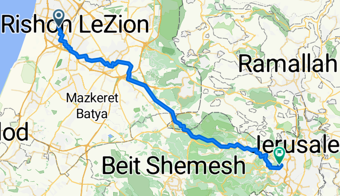
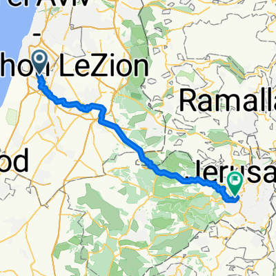
Embark on an exhilarating cycling adventure starting at HaSira Street 8 in Rishon Leziyyon, where your journey will lead you to the majestic Mount Herzl in Jerusalem. This scenic route covers a total distance of 63.0 km, featuring a delightful ascent of 1440 meters and a gentle descent of 660 meters. The route reaches its peak elevation of 833 meters, offering breathtaking views along the way.
The cycling surface is a mix of asphalt, gravel, and undefined terrain. You'll ride on asphalt for 11,161 meters, accounting for 17.7% of the total distance. Gravel paths make up 8,113 meters, or 12.9% of your journey, while undefined surfaces cover the majority, totaling 37,699 meters, which is 59.9% of the route.
The route is predominantly on tracks, making up 30,586 meters or 48.6% of your ride. Roads make up 13,962 meters, or 22.2% of your journey, while busy roads add 6,432 meters, accounting for 10.2% of the distance. The entire route is part of the undefined bike network, ensuring a smooth and uninterrupted ride.
Enjoy the thrill of cycling through diverse landscapes, from urban streets to serene countryside paths, as you make your way to Mount Herzl. This route promises a thrilling mix of paved and unpaved sections, challenging yet rewarding for all levels of cyclists.
AI generated
- 3 h 54 min
- Duration
- 63 km
- Distance
- 1,440 m
- Ascent
- 661 m
- Descent
- 16.1 km/h
- Avg. speed
- 834 m
- Max. altitude
Route quality
Waytypes & surfaces along the route
Waytypes
Track
30.9 km
(49 %)
Road
14.5 km
(23 %)
Surfaces
Paved
11.3 km
(18 %)
Unpaved
13.9 km
(22 %)
Asphalt
11.3 km
(18 %)
Gravel
8.2 km
(13 %)
Continue with Bikemap
Use, edit, or download this cycling route
You would like to ride road to Jerusalem or customize it for your own trip? Here is what you can do with this Bikemap route:
Free features
- Save this route as favorite or in collections
- Copy & plan your own version of this route
- Sync your route with Garmin or Wahoo
Premium features
Free trial for 3 days, or one-time payment. More about Bikemap Premium.
- Navigate this route on iOS & Android
- Export a GPX / KML file of this route
- Create your custom printout (try it for free)
- Download this route for offline navigation
Discover more Premium features.
Get Bikemap PremiumFrom our community
Other popular routes starting in Rishon LeZiyyon
 GOSTY to Petah Tikva
- Distance
- 18.1 km
- Ascent
- 68 m
- Descent
- 64 m
- Location
- Rishon LeZiyyon, Central District, Israel
 סובב שכונות מערב ראשון לציון
- Distance
- 11.8 km
- Ascent
- 65 m
- Descent
- 67 m
- Location
- Rishon LeZiyyon, Central District, Israel
 Moshe Beker Street 13, Rishon LeTsiyon to Ha-Vered Street 8, Rishon LeTsiyon
- Distance
- 4 km
- Ascent
- 59 m
- Descent
- 39 m
- Location
- Rishon LeZiyyon, Central District, Israel
 road to Jerusalem
- Distance
- 63 km
- Ascent
- 1,440 m
- Descent
- 661 m
- Location
- Rishon LeZiyyon, Central District, Israel
 Slow ride
- Distance
- 20.9 km
- Ascent
- 142 m
- Descent
- 136 m
- Location
- Rishon LeZiyyon, Central District, Israel
 NES up-down
- Distance
- 107.4 km
- Ascent
- 1,087 m
- Descent
- 1,086 m
- Location
- Rishon LeZiyyon, Central District, Israel
 סובב נס הרים
- Distance
- 129.2 km
- Ascent
- 941 m
- Descent
- 967 m
- Location
- Rishon LeZiyyon, Central District, Israel
 to work
- Distance
- 16.6 km
- Ascent
- 71 m
- Descent
- 123 m
- Location
- Rishon LeZiyyon, Central District, Israel
Open it in the app