

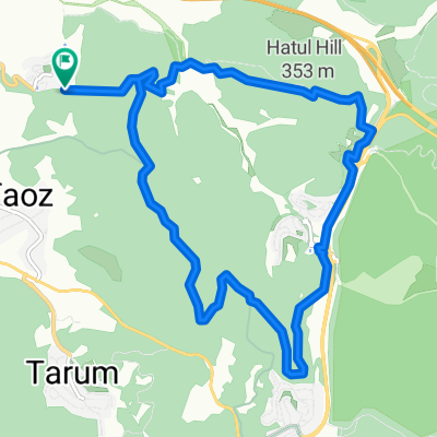
Israel Track, Latrun to Israel Track, Latrun
A cycling route starting in Bayt Liqyā, West Bank, Palestine.
Overview
About this route
- 2 h 4 min
- Duration
- 16.1 km
- Distance
- 322 m
- Ascent
- 320 m
- Descent
- 7.8 km/h
- Avg. speed
- 397 m
- Max. altitude

Route quality
Waytypes & surfaces along the route
Waytypes
Track
13.8 km
(86 %)
Quiet road
1.1 km
(7 %)
Surfaces
Unpaved
10.9 km
(68 %)
Gravel
10 km
(62 %)
Unpaved (undefined)
0.6 km
(4 %)
Continue with Bikemap
Use, edit, or download this cycling route
You would like to ride Israel Track, Latrun to Israel Track, Latrun or customize it for your own trip? Here is what you can do with this Bikemap route:
Free features
- Save this route as favorite or in collections
- Copy & plan your own version of this route
- Sync your route with Garmin or Wahoo
Premium features
Free trial for 3 days, or one-time payment. More about Bikemap Premium.
- Navigate this route on iOS & Android
- Export a GPX / KML file of this route
- Create your custom printout (try it for free)
- Download this route for offline navigation
Discover more Premium features.
Get Bikemap PremiumFrom our community
Other popular routes starting in Bayt Liqyā
 Neve Shalom to Messilat Zion v.v. Track
- Distance
- 16.3 km
- Ascent
- 357 m
- Descent
- 355 m
- Location
- Bayt Liqyā, West Bank, Palestine
 Israel Track, Latrun to Israel Track, Latrun
- Distance
- 16.1 km
- Ascent
- 322 m
- Descent
- 320 m
- Location
- Bayt Liqyā, West Bank, Palestine
 Neve Shalom 2
- Distance
- 10.9 km
- Ascent
- 180 m
- Descent
- 188 m
- Location
- Bayt Liqyā, West Bank, Palestine
 נוה שלום,מצ.שער הגיא,סן מרטין
- Distance
- 15.5 km
- Ascent
- 350 m
- Descent
- 351 m
- Location
- Bayt Liqyā, West Bank, Palestine
 friday
- Distance
- 36.5 km
- Ascent
- 767 m
- Descent
- 775 m
- Location
- Bayt Liqyā, West Bank, Palestine
 נוה שלום, בורמה, מסילת ציון
- Distance
- 15.9 km
- Ascent
- 243 m
- Descent
- 243 m
- Location
- Bayt Liqyā, West Bank, Palestine
 פארק קנדה 2
- Distance
- 6.8 km
- Ascent
- 19 m
- Descent
- 17 m
- Location
- Bayt Liqyā, West Bank, Palestine
 Route to 31.827° N 35.023° W
- Distance
- 7.9 km
- Ascent
- 236 m
- Descent
- 231 m
- Location
- Bayt Liqyā, West Bank, Palestine
Open it in the app