


DESAFIO RURAL LIGHT #3 SALESOPOLIS
- 35.8 km
- 918 m
- 917 m
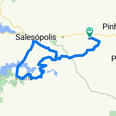
- Santa Branca, São Paulo, Brazil
A cycling route starting in Santa Branca, São Paulo, Brazil.
Overview
The first 26 km are predominantly uphill. The trail is usually shrouded in mist and has sections of drizzle. There is also a lot of gravel, and the wet ground from the mist and drizzle makes progress a bit difficult (at least in the first part). Regarding the descent, one should descend by braking, unless one intends to 'hit the ground' due to the wet ground and the large number of existing holes. The ideal time to go is in the driest season, between May and September - although it always rains in the region. It's worth it, especially for the view - if you're lucky enough not to have clouds, they say you can see the sea. If anyone manages to see it, let me know..... haha. This trail is intermediate to advanced due to the large number of climbs.
created this 13 years ago
Route quality
Road
47.6 km
(67 %)
Quiet road
21.3 km
(30 %)
Undefined
2.1 km
(3 %)
Paved
11.4 km
(16 %)
Unpaved
46.2 km
(65 %)
Unpaved (undefined)
44.1 km
(62 %)
Asphalt
9.9 km
(14 %)
Continue with Bikemap
You would like to ride Salesópolis à Caraguatatuba - Estrada da Petrobras or customize it for your own trip? Here is what you can do with this Bikemap route:
Free trial for 3 days, or one-time payment. More about Bikemap Premium.
Discover more Premium features.
Get Bikemap PremiumFrom our community
Open it in the app


