

Berlin - Mannheim
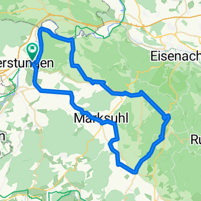
Dankmarshausen - Lauterbach / Hessen
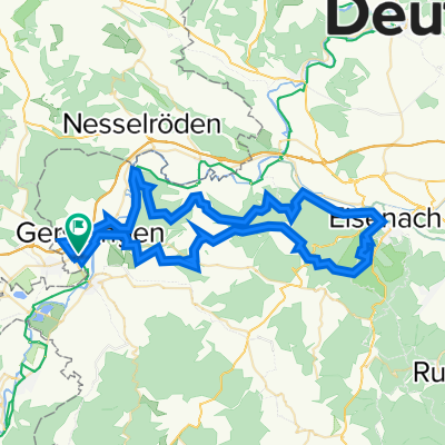
A cycling route starting in Gerstungen, Thuringia, Germany.
Overview
About this route
- 5 h 19 min
- Duration
- 93.7 km
- Distance
- 838 m
- Ascent
- 639 m
- Descent
- 17.6 km/h
- Avg. speed
- 418 m
- Max. altitude

Part of
Berlin - Mannheim
8 stages
Route quality
Waytypes & surfaces along the route
Waytypes
Track
37.5 km
(40 %)
Path
21.6 km
(23 %)
Surfaces
Paved
86.2 km
(92 %)
Unpaved
0.9 km
(1 %)
Asphalt
80.6 km
(86 %)
Concrete
5.6 km
(6 %)
Continue with Bikemap
Use, edit, or download this cycling route
You would like to ride Dankmarshausen - Lauterbach / Hessen or customize it for your own trip? Here is what you can do with this Bikemap route:
Free features
- Save this route as favorite or in collections
- Copy & plan your own version of this route
- Split it into stages to create a multi-day tour
- Sync your route with Garmin or Wahoo
Premium features
Free trial for 3 days, or one-time payment. More about Bikemap Premium.
- Navigate this route on iOS & Android
- Export a GPX / KML file of this route
- Create your custom printout (try it for free)
- Download this route for offline navigation
Discover more Premium features.
Get Bikemap PremiumFrom our community
Other popular routes starting in Gerstungen
 Untersuhl- Berka- Abteroda- Springen- Kieselbach- Krayenburg- Tiefenort- Dönges- Fernbreitenbach- Gerstungen- Untersuhl
- Distance
- 51.1 km
- Ascent
- 755 m
- Descent
- 755 m
- Location
- Gerstungen, Thuringia, Germany
 6 HeimatTour GPX3_Garmin
- Distance
- 83.6 km
- Ascent
- 481 m
- Descent
- 457 m
- Location
- Gerstungen, Thuringia, Germany
 Untersuhl- Kratzeroda- Sallmannshäuser Rennsteig- Unterellen- Rangenhof- Clausberg- Sängerwiese- Wartburg- ESA- Stedtfelder Teiche- Lauchröden- Böller- Sallmann
- Distance
- 63.7 km
- Ascent
- 2,040 m
- Descent
- 2,262 m
- Location
- Gerstungen, Thuringia, Germany
 Untersuhl-Säulingswald- Untersuhl
- Distance
- 69.3 km
- Ascent
- 1,249 m
- Descent
- 1,250 m
- Location
- Gerstungen, Thuringia, Germany
 Dankmarshausen - Lauterbach / Hessen
- Distance
- 93.7 km
- Ascent
- 838 m
- Descent
- 639 m
- Location
- Gerstungen, Thuringia, Germany
 Untersuhl-Berka-Napoleonweg-Abteroda-Oberzella-Philippsthal-Heringen-Dankmarshausen-Obersuhl-Untersuhl
- Distance
- 42.2 km
- Ascent
- 408 m
- Descent
- 410 m
- Location
- Gerstungen, Thuringia, Germany
 Berka/Werra - 57,4 km, 331 hm
- Distance
- 57.4 km
- Ascent
- 403 m
- Descent
- 403 m
- Location
- Gerstungen, Thuringia, Germany
 Untersuhl-Berka-Horschlitt-Wünschensuhler Straße-Willkommen-Frauensee-Kreuz-Abteroda-Dippach-Dankmarshausen-Untersuhl
- Distance
- 36.7 km
- Ascent
- 457 m
- Descent
- 459 m
- Location
- Gerstungen, Thuringia, Germany
Open it in the app