
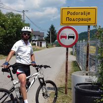
Mehmedalije Maka Dizdara to GMJV+95H
A cycling route starting in Tuzla, Federation of Bosnia and Herzegovina, Bosnia and Herzegovina.
Overview
About this route
- 46 min
- Duration
- 11.5 km
- Distance
- 39 m
- Ascent
- 86 m
- Descent
- 14.9 km/h
- Avg. speed
- 286 m
- Max. altitude

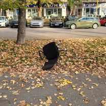
Route photos

Continue with Bikemap
Use, edit, or download this cycling route
You would like to ride Mehmedalije Maka Dizdara to GMJV+95H or customize it for your own trip? Here is what you can do with this Bikemap route:
Free features
- Save this route as favorite or in collections
- Copy & plan your own version of this route
- Sync your route with Garmin or Wahoo
Premium features
Free trial for 3 days, or one-time payment. More about Bikemap Premium.
- Navigate this route on iOS & Android
- Export a GPX / KML file of this route
- Create your custom printout (try it for free)
- Download this route for offline navigation
Discover more Premium features.
Get Bikemap PremiumFrom our community
Other popular routes starting in Tuzla
 Irac,Grabovica,Tetima,HPJX+F5J, Kosci
- Distance
- 14.1 km
- Ascent
- 628 m
- Descent
- 359 m
- Location
- Tuzla, Federation of Bosnia and Herzegovina, Bosnia and Herzegovina
 Tuzla-Čelić-Tuzla
- Distance
- 76.4 km
- Ascent
- 981 m
- Descent
- 979 m
- Location
- Tuzla, Federation of Bosnia and Herzegovina, Bosnia and Herzegovina
 bike tour from 22/06/16 12:40
- Distance
- 19.8 km
- Ascent
- 167 m
- Descent
- 167 m
- Location
- Tuzla, Federation of Bosnia and Herzegovina, Bosnia and Herzegovina
 Amalije Lebeničnik to Amalije Lebeničnik
- Distance
- 15.2 km
- Ascent
- 402 m
- Descent
- 402 m
- Location
- Tuzla, Federation of Bosnia and Herzegovina, Bosnia and Herzegovina
 GMJV+95H to Mehmedalije Maka Dizdara
- Distance
- 10.8 km
- Ascent
- 58 m
- Descent
- 101 m
- Location
- Tuzla, Federation of Bosnia and Herzegovina, Bosnia and Herzegovina
 11. biciklijada Tuzla
- Distance
- 14 km
- Ascent
- 39 m
- Descent
- 38 m
- Location
- Tuzla, Federation of Bosnia and Herzegovina, Bosnia and Herzegovina
 Mehmedalije Maka Dizdara to GMJV+95H
- Distance
- 11.5 km
- Ascent
- 39 m
- Descent
- 86 m
- Location
- Tuzla, Federation of Bosnia and Herzegovina, Bosnia and Herzegovina
 Krug oko Majevice
- Distance
- 97.1 km
- Ascent
- 1,792 m
- Descent
- 1,808 m
- Location
- Tuzla, Federation of Bosnia and Herzegovina, Bosnia and Herzegovina
Open it in the app