
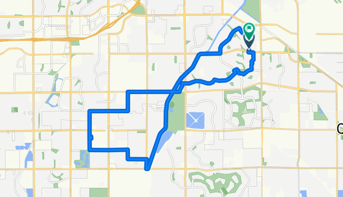
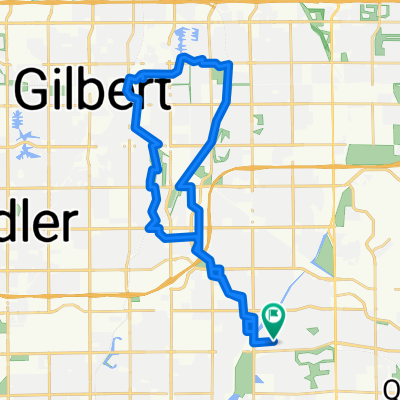
S Vineyard Ave, Gilbert to S Vineyard Ave, Gilbert
A cycling route starting in Queen Creek, Arizona, United States.
Overview
About this route
Embark on a smooth and enjoyable cycling adventure that spans 23.9 kilometers. The route features a gentle ascent of 38 meters and a gradual descent of 40 meters, leading you to a maximum elevation of 408 meters.
You'll primarily ride on paved surfaces, covering 13,269 meters (55.6%) of the journey. Additionally, there are stretches on unpaved paths, comprising 10,615 meters (44.4%).
The route includes a mix of quiet roads, access roads, busy roads, and roads, providing a diverse experience. As a cyclist, you'll enjoy the quiet roads for a significant portion of your ride, covering 9,578 meters (40.1%).
This cycling route is well-integrated into the local bike network, ensuring a seamless and connected experience.
AI generated
- 1 h 31 min
- Duration
- 23.9 km
- Distance
- 39 m
- Ascent
- 41 m
- Descent
- 15.8 km/h
- Avg. speed
- 409 m
- Max. altitude

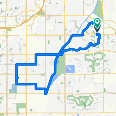
Route quality
Waytypes & surfaces along the route
Waytypes
Quiet road
9.6 km
(40 %)
Access road
7.2 km
(30 %)
Surfaces
Paved
13.4 km
(56 %)
Asphalt
13.4 km
(56 %)
Undefined
10.5 km
(44 %)
Continue with Bikemap
Use, edit, or download this cycling route
You would like to ride S Vineyard Ave, Gilbert to S Vineyard Ave, Gilbert or customize it for your own trip? Here is what you can do with this Bikemap route:
Free features
- Save this route as favorite or in collections
- Copy & plan your own version of this route
- Sync your route with Garmin or Wahoo
Premium features
Free trial for 3 days, or one-time payment. More about Bikemap Premium.
- Navigate this route on iOS & Android
- Export a GPX / KML file of this route
- Create your custom printout (try it for free)
- Download this route for offline navigation
Discover more Premium features.
Get Bikemap PremiumFrom our community
Other popular routes starting in Queen Creek
 S Vineyard Ave, Gilbert to S Vineyard Ave, Gilbert
- Distance
- 23.9 km
- Ascent
- 39 m
- Descent
- 41 m
- Location
- Queen Creek, Arizona, United States
 S Rim Rd, Gilbert to E Lantern Ct, Gilbert
- Distance
- 12.4 km
- Ascent
- 20 m
- Descent
- 34 m
- Location
- Queen Creek, Arizona, United States
 Queen Creek
- Distance
- 20.2 km
- Ascent
- 57 m
- Descent
- 63 m
- Location
- Queen Creek, Arizona, United States
 here to tray
- Distance
- 21.7 km
- Ascent
- 54 m
- Descent
- 12 m
- Location
- Queen Creek, Arizona, United States
 Parents McQueen Loop (27 Miles)
- Distance
- 44.3 km
- Ascent
- 117 m
- Descent
- 114 m
- Location
- Queen Creek, Arizona, United States
 Route in Gilbert
- Distance
- 38.3 km
- Ascent
- 57 m
- Descent
- 56 m
- Location
- Queen Creek, Arizona, United States
 Ride to Riparian
- Distance
- 15.5 km
- Ascent
- 17 m
- Descent
- 25 m
- Location
- Queen Creek, Arizona, United States
 to frys
- Distance
- 3.7 km
- Ascent
- 8 m
- Descent
- 5 m
- Location
- Queen Creek, Arizona, United States
Open it in the app