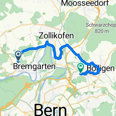
Hohstalenweg, Herrenschwanden nach Vorderer Schermen, Ittigen
- 11.7 km
- 152 m
- 199 m
- Kirchlindach, Canton of Bern, Switzerland
A cycling route starting in Kirchlindach, Canton of Bern, Switzerland.
Overview
Embark on an exhilarating cycling adventure along this scenic route, spanning 11.7 kilometers with a delightful mix of climbs and descents. Begin your journey by navigating gentle slopes, gradually building your stamina as you ascend to a maximum elevation of 607 meters. The route offers a rewarding 152 meters of ascent and a thrilling 199 meters of descent, providing an ideal balance of challenge and enjoyment.
The surface is a mix of paved paths and gravel, ensuring a smooth yet engaging ride. As you cycle through picturesque landscapes, the elevation changes will keep you motivated and energized. Whether you're a seasoned cyclist or just starting out,
AI generated
created this 1 month ago
Route quality
Quiet road
6.1 km
(52 %)
Road
3.8 km
(32 %)
Paved
9.1 km
(78 %)
Unpaved
1.3 km
(11 %)
Asphalt
8.6 km
(73 %)
Gravel
0.7 km
(6 %)
Continue with Bikemap
You would like to ride Hohstalenweg, Herrenschwanden nach Vorderer Schermen, Ittigen or customize it for your own trip? Here is what you can do with this Bikemap route:
Free trial for 3 days, or one-time payment. More about Bikemap Premium.
Discover more Premium features.
Get Bikemap PremiumFrom our community
Open it in the app