
Von Görlitz bis Ueckermünde
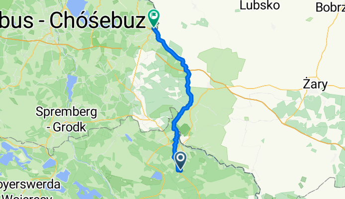
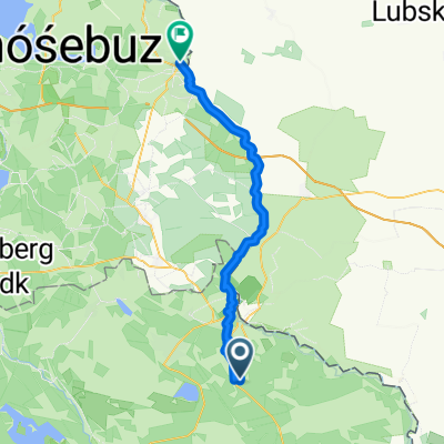
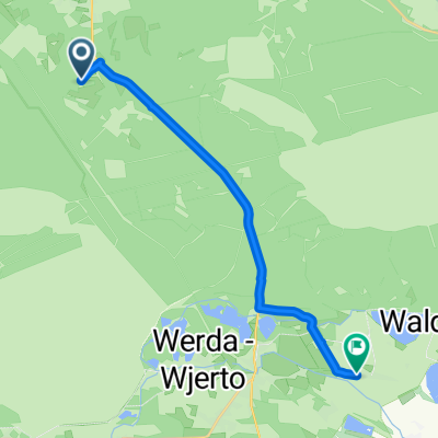
Rietschen - Brody
A cycling route starting in Weißkeißel, Saxony, Germany.
Overview
About this route
- 2 h 25 min
- Duration
- 40.8 km
- Distance
- 268 m
- Ascent
- 332 m
- Descent
- 16.9 km/h
- Avg. speed
- 167 m
- Max. altitude
Part of
Von Görlitz bis Ueckermünde
10 stages
Route quality
Waytypes & surfaces along the route
Waytypes
Path
17.1 km
(42 %)
Quiet road
11.8 km
(29 %)
Surfaces
Paved
32.2 km
(79 %)
Unpaved
4.1 km
(10 %)
Asphalt
29.8 km
(73 %)
Paved (undefined)
2.4 km
(6 %)
Continue with Bikemap
Use, edit, or download this cycling route
You would like to ride Rietschen - Brody or customize it for your own trip? Here is what you can do with this Bikemap route:
Free features
- Save this route as favorite or in collections
- Copy & plan your own version of this route
- Sync your route with Garmin or Wahoo
Premium features
Free trial for 3 days, or one-time payment. More about Bikemap Premium.
- Navigate this route on iOS & Android
- Export a GPX / KML file of this route
- Create your custom printout (try it for free)
- Download this route for offline navigation
Discover more Premium features.
Get Bikemap PremiumFrom our community
Other popular routes starting in Weißkeißel
 Route nach Rietschener Straße 4A, Boxberg/Oberlausitz
- Distance
- 17.8 km
- Ascent
- 43 m
- Descent
- 50 m
- Location
- Weißkeißel, Saxony, Germany
 Brandstraße 24, Krauschwitz nach Spreegasse 11, Bautzen
- Distance
- 59.9 km
- Ascent
- 126 m
- Descent
- 88 m
- Location
- Weißkeißel, Saxony, Germany
 Görlitzer Straße, Weißkeißel nach Rietschen, Rietschen
- Distance
- 9.9 km
- Ascent
- 36 m
- Descent
- 19 m
- Location
- Weißkeißel, Saxony, Germany
 Rietschen - Brody
- Distance
- 40.8 km
- Ascent
- 268 m
- Descent
- 332 m
- Location
- Weißkeißel, Saxony, Germany
 Dorfstraße nach Dorfstraße
- Distance
- 13.4 km
- Ascent
- 60 m
- Descent
- 79 m
- Location
- Weißkeißel, Saxony, Germany
 Erlenweg 2, Weißkeißel do S127, Krauschwitz
- Distance
- 5.5 km
- Ascent
- 119 m
- Descent
- 120 m
- Location
- Weißkeißel, Saxony, Germany
 B156, Weißkeißel nach Unnamed Road, Hamor
- Distance
- 4.5 km
- Ascent
- 31 m
- Descent
- 21 m
- Location
- Weißkeißel, Saxony, Germany
 Unnamed Road, Hamor nach Unnamed Road, Hamor
- Distance
- 0.3 km
- Ascent
- 0 m
- Descent
- 1 m
- Location
- Weißkeißel, Saxony, Germany
Open it in the app