Seestrasse, Lenk im Simmental nach Leiterliweg, Lenk im Simmental
- 11.2 km
- 940 m
- 68 m
- Lenk, Canton of Bern, Switzerland
A cycling route starting in Lenk, Canton of Bern, Switzerland.
Overview
Embark on a scenic cycling adventure starting from Seestrasse 4 in Lenk im Simmental. The route unfolds over 11.2 km, with an elevation gain of 939 meters and a descent of 68 meters. The journey peaks at a maximum elevation of 1937 meters.
The terrain is a mix of asphalt and gravel, with asphalt dominating 65.9% of the route, offering a smooth ride for most of the way. Gravel sections add a bit of challenge and interest, covering 28.6% of the path.
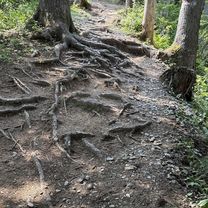
You'll navigate through picturesque forest paths, comprising 54.9% of the route, providing a refreshing change of scenery. Additionally, there are stretches on paved roads making up 38.9% of the journey, ensuring a comfortable ride on well-maintained surfaces.
This cycling route is part of the larger cycling network, stretching an impressive total of 11,214 meters. So, gear up for an engaging ride through Lenk im Simmental, combining smooth paths, gravel tracks, and scenic forest vistas. Enjoy the ride!
AI generated
created this 1 month ago
Route quality
Track
6.2 km
(55 %)
Road
4.4 km
(39 %)
Paved
8 km
(71 %)
Unpaved
3.3 km
(29 %)
Asphalt
8 km
(71 %)
Gravel
3.3 km
(29 %)
Continue with Bikemap
You would like to ride Seestrasse, Lenk im Simmental nach Leiterliweg, Lenk im Simmental or customize it for your own trip? Here is what you can do with this Bikemap route:
Free trial for 3 days, or one-time payment. More about Bikemap Premium.
Discover more Premium features.
Get Bikemap PremiumFrom our community
Open it in the app