
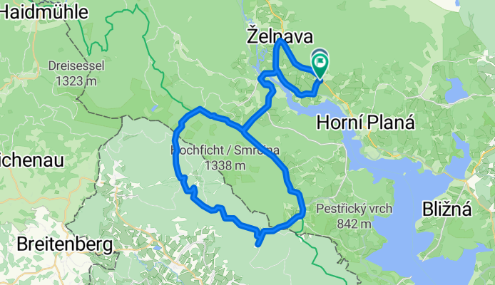
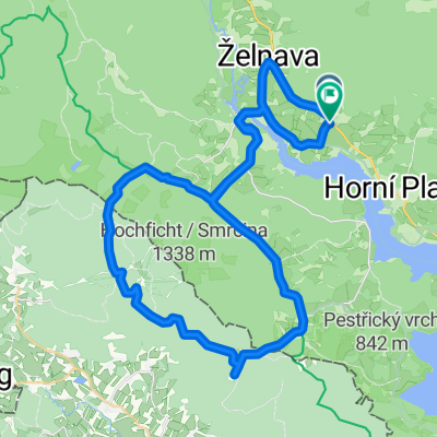
Pernek, Horní Planá nach Pernek, Horní Planá
A cycling route starting in Horní Planá, Jihočeský kraj, Czechia.
Overview
About this route
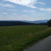
Embark on an exhilarating 45.9 km cycling adventure that will test your limits and reward you with breathtaking views. As you set out, enjoy the thrill of conquering an ascent of 736 meters, with a gentle descent of 737 meters that keeps the energy flowing.
Reaching a maximum elevation of 1025 meters, this route promises an invigorating challenge for cyclists of all levels. The varied terrain and engaging gradients make for a dynamic ride, perfect for those seeking both adventure and a touch of challenge.
Whether you're a seasoned cyclist or just looking to explore new trails, this route offers an unforgettable experience. So gear up, embrace the challenge, and enjoy the ride!
AI generated
- 3 h 12 min
- Duration
- 45.9 km
- Distance
- 737 m
- Ascent
- 738 m
- Descent
- 14.4 km/h
- Avg. speed
- 1,025 m
- Max. altitude

Route quality
Waytypes & surfaces along the route
Waytypes
Track
23.4 km
(51 %)
Road
11.5 km
(25 %)
Surfaces
Paved
24.3 km
(53 %)
Unpaved
11 km
(24 %)
Asphalt
18.8 km
(41 %)
Gravel
11 km
(24 %)
Continue with Bikemap
Use, edit, or download this cycling route
You would like to ride Pernek, Horní Planá nach Pernek, Horní Planá or customize it for your own trip? Here is what you can do with this Bikemap route:
Free features
- Save this route as favorite or in collections
- Copy & plan your own version of this route
- Sync your route with Garmin or Wahoo
Premium features
Free trial for 3 days, or one-time payment. More about Bikemap Premium.
- Navigate this route on iOS & Android
- Export a GPX / KML file of this route
- Create your custom printout (try it for free)
- Download this route for offline navigation
Discover more Premium features.
Get Bikemap PremiumFrom our community
Other popular routes starting in Horní Planá
 Lipno Juh
- Distance
- 57.5 km
- Ascent
- 509 m
- Descent
- 505 m
- Location
- Horní Planá, Jihočeský kraj, Czechia
 Zaznamenáno přes Apple Watch na 23. 7. 17:24
- Distance
- 48.7 km
- Ascent
- 632 m
- Descent
- 1,336 m
- Location
- Horní Planá, Jihočeský kraj, Czechia
 kolem Schwarzenberského kanálu
- Distance
- 49.1 km
- Ascent
- 315 m
- Descent
- 315 m
- Location
- Horní Planá, Jihočeský kraj, Czechia
 Pernek, Horní Planá nach Pernek, Horní Planá
- Distance
- 45.9 km
- Ascent
- 737 m
- Descent
- 738 m
- Location
- Horní Planá, Jihočeský kraj, Czechia
 Lipno 06
- Distance
- 50.1 km
- Ascent
- 592 m
- Descent
- 597 m
- Location
- Horní Planá, Jihočeský kraj, Czechia
 Černá v Pošumaví, Černá v Pošumaví nach Frymburk, Frymburk
- Distance
- 18.2 km
- Ascent
- 265 m
- Descent
- 289 m
- Location
- Horní Planá, Jihočeský kraj, Czechia
 Lipno sever
- Distance
- 62.6 km
- Ascent
- 469 m
- Descent
- 459 m
- Location
- Horní Planá, Jihočeský kraj, Czechia
 Moldausee Mitte
- Distance
- 37.8 km
- Ascent
- 467 m
- Descent
- 460 m
- Location
- Horní Planá, Jihočeský kraj, Czechia
Open it in the app