
Alpencross: Füssen - Meran über die Via Claudia Augusta
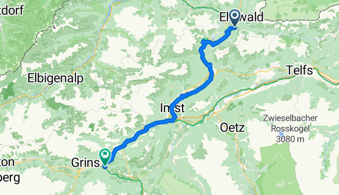
Biberwier - Landeck
A cycling route starting in Biberwier, Tyrol, Austria.
Overview
About this route
- 3 h 19 min
- Duration
- 53.5 km
- Distance
- 427 m
- Ascent
- 736 m
- Descent
- 16.1 km/h
- Avg. speed
- 1,256 m
- Max. altitude

Part of
Continue with Bikemap
Use, edit, or download this cycling route
You would like to ride Biberwier - Landeck or customize it for your own trip? Here is what you can do with this Bikemap route:
Free features
- Save this route as favorite or in collections
- Copy & plan your own version of this route
- Sync your route with Garmin or Wahoo
Premium features
Free trial for 3 days, or one-time payment. More about Bikemap Premium.
- Navigate this route on iOS & Android
- Export a GPX / KML file of this route
- Create your custom printout (try it for free)
- Download this route for offline navigation
Discover more Premium features.
Get Bikemap PremiumFrom our community
Other popular routes starting in Biberwier
 L71 64, Biberwier nach Malserstraße 31, Landeck
- Distance
- 54.4 km
- Ascent
- 651 m
- Descent
- 852 m
- Location
- Biberwier, Tyrol, Austria
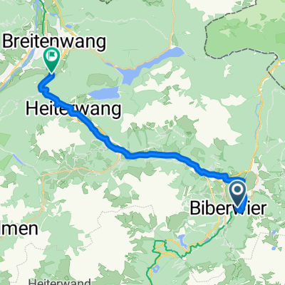 Biberwier - Breitenwang
- Distance
- 22.7 km
- Ascent
- 435 m
- Descent
- 490 m
- Location
- Biberwier, Tyrol, Austria
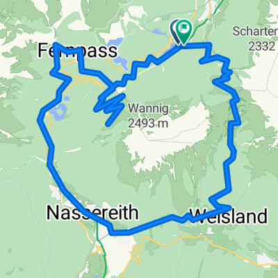 L71 nach Fernpass
- Distance
- 40.8 km
- Ascent
- 2,271 m
- Descent
- 2,263 m
- Location
- Biberwier, Tyrol, Austria
 E2: Biberwier - Zernez
- Distance
- 138.7 km
- Ascent
- 2,893 m
- Descent
- 2,461 m
- Location
- Biberwier, Tyrol, Austria
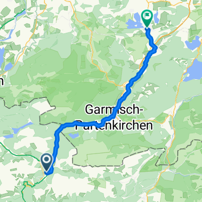 Biberwier - Murnau am Staffelsee
- Distance
- 54.2 km
- Ascent
- 256 m
- Descent
- 570 m
- Location
- Biberwier, Tyrol, Austria
 Biberwier - Landeck
- Distance
- 53.5 km
- Ascent
- 427 m
- Descent
- 736 m
- Location
- Biberwier, Tyrol, Austria
 OETZ 08 Biberwier
- Distance
- 21.1 km
- Ascent
- 658 m
- Descent
- 649 m
- Location
- Biberwier, Tyrol, Austria
 Mühlsteig, Biberwier nach Sameranger I, Nassereith
- Distance
- 13.3 km
- Ascent
- 356 m
- Descent
- 388 m
- Location
- Biberwier, Tyrol, Austria
Open it in the app