

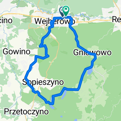
Ofiar Piaśnicy, Wejherowo to Ofiar Piaśnicy, Wejherowo
A cycling route starting in Wejherowo, Pomeranian Voivodeship, Poland.
Overview
About this route
- 2 h 5 min
- Duration
- 35.7 km
- Distance
- 1,049 m
- Ascent
- 1,051 m
- Descent
- 17.2 km/h
- Avg. speed
- 111 m
- Max. altitude
Continue with Bikemap
Use, edit, or download this cycling route
You would like to ride Ofiar Piaśnicy, Wejherowo to Ofiar Piaśnicy, Wejherowo or customize it for your own trip? Here is what you can do with this Bikemap route:
Free features
- Save this route as favorite or in collections
- Copy & plan your own version of this route
- Sync your route with Garmin or Wahoo
Premium features
Free trial for 3 days, or one-time payment. More about Bikemap Premium.
- Navigate this route on iOS & Android
- Export a GPX / KML file of this route
- Create your custom printout (try it for free)
- Download this route for offline navigation
Discover more Premium features.
Get Bikemap PremiumFrom our community
Other popular routes starting in Wejherowo
 Ofiar Piaśnicy, Wejherowo to Ofiar Piaśnicy, Wejherowo
- Distance
- 35.7 km
- Ascent
- 1,049 m
- Descent
- 1,051 m
- Location
- Wejherowo, Pomeranian Voivodeship, Poland
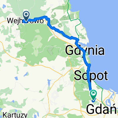 Wejherowo Gdynia
- Distance
- 51 km
- Ascent
- 176 m
- Descent
- 153 m
- Location
- Wejherowo, Pomeranian Voivodeship, Poland
 Hieronima Derdowskiego 6, Wejherowo do Hieronima Derdowskiego 6, Wejherowo
- Distance
- 69.9 km
- Ascent
- 941 m
- Descent
- 932 m
- Location
- Wejherowo, Pomeranian Voivodeship, Poland
 MTh_Wejh_Borowo_1
- Distance
- 29.6 km
- Ascent
- 397 m
- Descent
- 399 m
- Location
- Wejherowo, Pomeranian Voivodeship, Poland
 Hura hura dzisiaj Białogóra, marynara i fryzura..oj chyba nie tak to leciało 😉
- Distance
- 37.4 km
- Ascent
- 266 m
- Descent
- 320 m
- Location
- Wejherowo, Pomeranian Voivodeship, Poland
 trasa
trasa- Distance
- 19 km
- Ascent
- 299 m
- Descent
- 157 m
- Location
- Wejherowo, Pomeranian Voivodeship, Poland
 Rajd, Szlak Lęborski, Wejherowo-Przetoczyno-Lębork
- Distance
- 62.8 km
- Ascent
- 1,242 m
- Descent
- 1,249 m
- Location
- Wejherowo, Pomeranian Voivodeship, Poland
 Rajd, Szlak Trójmiejskiego Parku Krajobrazowego, Wejherowo-Zbychowo-Łężyce-Gdynia-Sopot
- Distance
- 67.3 km
- Ascent
- 1,536 m
- Descent
- 1,572 m
- Location
- Wejherowo, Pomeranian Voivodeship, Poland
Open it in the app