

Wien Toulon
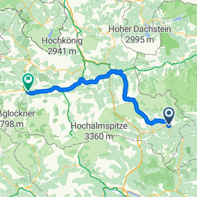
04 Von Tamsweg bis Bruck an der Großglocknerstraße
A cycling route starting in Tamsweg, Salzburg, Austria.
Overview
About this route
- 6 h 28 min
- Duration
- 115.2 km
- Distance
- 2,519 m
- Ascent
- 2,782 m
- Descent
- 17.8 km/h
- Avg. speed
- 1,759 m
- Max. altitude
Part of
Wien Toulon
8 stages
Route quality
Waytypes & surfaces along the route
Waytypes
Quiet road
35.7 km
(31 %)
Road
17.3 km
(15 %)
Surfaces
Paved
97.9 km
(85 %)
Asphalt
96.8 km
(84 %)
Paved (undefined)
1.2 km
(1 %)
Undefined
17.3 km
(15 %)
Continue with Bikemap
Use, edit, or download this cycling route
You would like to ride 04 Von Tamsweg bis Bruck an der Großglocknerstraße or customize it for your own trip? Here is what you can do with this Bikemap route:
Free features
- Save this route as favorite or in collections
- Copy & plan your own version of this route
- Split it into stages to create a multi-day tour
- Sync your route with Garmin or Wahoo
Premium features
Free trial for 3 days, or one-time payment. More about Bikemap Premium.
- Navigate this route on iOS & Android
- Export a GPX / KML file of this route
- Create your custom printout (try it for free)
- Download this route for offline navigation
Discover more Premium features.
Get Bikemap PremiumFrom our community
Other popular routes starting in Tamsweg
 Mura túra 2018
- Distance
- 38.1 km
- Ascent
- 95 m
- Descent
- 283 m
- Location
- Tamsweg, Salzburg, Austria
 Tamsweg bis Niederwölz
- Distance
- 66.6 km
- Ascent
- 1,112 m
- Descent
- 1,403 m
- Location
- Tamsweg, Salzburg, Austria
 04 Von Tamsweg bis Bruck an der Großglocknerstraße
- Distance
- 115.2 km
- Ascent
- 2,519 m
- Descent
- 2,782 m
- Location
- Tamsweg, Salzburg, Austria
 Murradweg_mit Squadra Volante
- Distance
- 210 km
- Ascent
- 1,566 m
- Descent
- 2,158 m
- Location
- Tamsweg, Salzburg, Austria
 Tag-1 Tamsweg bis Judenburg
- Distance
- 89.5 km
- Ascent
- 1,375 m
- Descent
- 1,646 m
- Location
- Tamsweg, Salzburg, Austria
 Mitterbergrunde
- Distance
- 27.4 km
- Ascent
- 129 m
- Descent
- 103 m
- Location
- Tamsweg, Salzburg, Austria
 Murradweg bis Fohnsdorf
- Distance
- 93.9 km
- Ascent
- 1,367 m
- Descent
- 1,655 m
- Location
- Tamsweg, Salzburg, Austria
 Thomatal
- Distance
- 40.9 km
- Ascent
- 320 m
- Descent
- 314 m
- Location
- Tamsweg, Salzburg, Austria
Open it in the app