

Triforest Traverse - Hellbender (Eastern Divide) - C+O
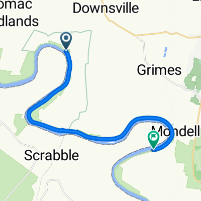
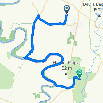
Cedar Grove to Point of Rocks
A cycling route starting in Saint James, Maryland, United States.
Overview
About this route
Start on - Turn left onto Avis Mill Road - Turn left onto Chesapeake and Ohio Canal Trail - Turn left onto Ferry Hill Plantation Path - Turn right onto Ferry Hill Plantation Path - Turn left onto Ferry Hill Plantation Path - Turn right onto Canal Road - Keep right - Turn slight left - Turn slight left onto Chesapeake and Ohio Canal Trail - Keep left onto Chesapeake and Ohio Canal Trail - Turn right - Turn left - Turn left onto Canal Road - Turn right onto Commerce Street - Turn left - Turn left - Keep left - FINISH
- 4 h 3 min
- Duration
- 66.3 km
- Distance
- 32 m
- Ascent
- 88 m
- Descent
- 16.4 km/h
- Avg. speed
- 125 m
- Max. altitude
Part of
Continue with Bikemap
Use, edit, or download this cycling route
You would like to ride Cedar Grove to Point of Rocks or customize it for your own trip? Here is what you can do with this Bikemap route:
Free features
- Save this route as favorite or in collections
- Copy & plan your own version of this route
- Sync your route with Garmin or Wahoo
Premium features
Free trial for 3 days, or one-time payment. More about Bikemap Premium.
- Navigate this route on iOS & Android
- Export a GPX / KML file of this route
- Create your custom printout (try it for free)
- Download this route for offline navigation
Discover more Premium features.
Get Bikemap PremiumFrom our community
Other popular routes starting in Saint James
 Recovered Route
- Distance
- 13.9 km
- Ascent
- 162 m
- Descent
- 149 m
- Location
- Saint James, Maryland, United States
 Circle to Antietam
- Distance
- 45 km
- Ascent
- 330 m
- Descent
- 354 m
- Location
- Saint James, Maryland, United States
 Rockland Drive 18303, Hagerstown to Rockland Drive 18303, Hagerstown
- Distance
- 0.4 km
- Ascent
- 0 m
- Descent
- 0 m
- Location
- Saint James, Maryland, United States
 Rockland Drive 18227, Hagerstown to Rockland Drive 18303, Hagerstown
- Distance
- 1.3 km
- Ascent
- 0 m
- Descent
- 10 m
- Location
- Saint James, Maryland, United States
 Quick rural to Antietam without Lappan
- Distance
- 18.2 km
- Ascent
- 141 m
- Descent
- 137 m
- Location
- Saint James, Maryland, United States
 Rockland Drive 18303, Hagerstown to Rockland Drive 18303, Hagerstown
- Distance
- 0.4 km
- Ascent
- 0 m
- Descent
- 0 m
- Location
- Saint James, Maryland, United States
 8602 Jordan Rd, Fairplay to 18100 Bloody Ln, Keedysville
- Distance
- 30 km
- Ascent
- 175 m
- Descent
- 167 m
- Location
- Saint James, Maryland, United States
 35 mile circuit
- Distance
- 55.5 km
- Ascent
- 388 m
- Descent
- 381 m
- Location
- Saint James, Maryland, United States
Open it in the app