

Hirschenstein - Rauher Kulm - Klosterstein
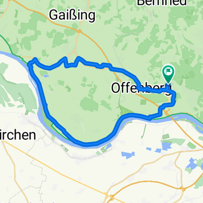
A cycling route starting in Offenberg, Bavaria, Germany.
Overview
About this route
Buchberg - Bernried - Böbrach - Grandsberg - Mühlgrabenweg - Hirschenstein - Rauher Kulm - Kalteck - Klosterstein - Oberhirschberg - Leithen - Buchberg
- -:--
- Duration
- 46.3 km
- Distance
- 1,316 m
- Ascent
- 1,317 m
- Descent
- ---
- Avg. speed
- ---
- Max. altitude
Route quality
Waytypes & surfaces along the route
Waytypes
Track
16.3 km
(35 %)
Path
15.8 km
(34 %)
Surfaces
Paved
13.4 km
(29 %)
Unpaved
22.4 km
(48 %)
Ground
15.3 km
(33 %)
Asphalt
13.3 km
(29 %)
Continue with Bikemap
Use, edit, or download this cycling route
You would like to ride Hirschenstein - Rauher Kulm - Klosterstein or customize it for your own trip? Here is what you can do with this Bikemap route:
Free features
- Save this route as favorite or in collections
- Copy & plan your own version of this route
- Sync your route with Garmin or Wahoo
Premium features
Free trial for 3 days, or one-time payment. More about Bikemap Premium.
- Navigate this route on iOS & Android
- Export a GPX / KML file of this route
- Create your custom printout (try it for free)
- Download this route for offline navigation
Discover more Premium features.
Get Bikemap PremiumFrom our community
Other popular routes starting in Offenberg
 route21.07.13 armin wolfgang
- Distance
- 28.8 km
- Ascent
- 929 m
- Descent
- 935 m
- Location
- Offenberg, Bavaria, Germany
 Radrunde von Mariaposching nach Offenberg
- Distance
- 14.4 km
- Ascent
- 39 m
- Descent
- 30 m
- Location
- Offenberg, Bavaria, Germany
 1: Deggendorg-Krems
- Distance
- 305.8 km
- Ascent
- 100 m
- Descent
- 285 m
- Location
- Offenberg, Bavaria, Germany
 Vakantie 2019 - DE - AU - CZ
- Distance
- 739 km
- Ascent
- 1,702 m
- Descent
- 1,704 m
- Location
- Offenberg, Bavaria, Germany
 Lindenanger nach Lindenanger
- Distance
- 31.4 km
- Ascent
- 51 m
- Descent
- 102 m
- Location
- Offenberg, Bavaria, Germany
 Hirschenstein - Rauher Kulm - Klosterstein
- Distance
- 46.3 km
- Ascent
- 1,316 m
- Descent
- 1,317 m
- Location
- Offenberg, Bavaria, Germany
 Schlögener Schleife
- Distance
- 106.3 km
- Ascent
- 1,227 m
- Descent
- 1,104 m
- Location
- Offenberg, Bavaria, Germany
 Bike Route 2
- Distance
- 86.2 km
- Ascent
- 145 m
- Descent
- 139 m
- Location
- Offenberg, Bavaria, Germany
Open it in the app