
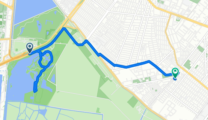
Boulevard Adolfo Ruiz Cortines, Xochimilco a Cerrada Océano, Tláhuac
A cycling route starting in Xochimilco, Mexico City, Mexico.
Overview
About this route
Embark on an exhilarating cycling adventure through the scenic countryside, where every pedal stroke brings you closer to breathtaking vistas. Starting your journey at a moderate elevation, you'll experience a gentle ascent of 23 meters, setting the stage for the thrill of the descent.
As you pedal forward, the path unfolds with a mix of smooth pavement and unpaved sections, offering a dynamic riding experience. The route ascends a little more, reaching a peak elevation of 2248 meters, providing a rewarding challenge for avid cyclists.
Descending with grace, you'll enjoy a gentle 12 meters drop, allowing you to savor the scenic beauty of the landscape below. This 8.0 km journey not only tests your cycling prowess but also immerses you in the tranquil charm of the area. Whether you're a seasoned cyclist or a curious adventurer, this route promises an unforgettable ride.
AI generated
- 45 min
- Duration
- 8 km
- Distance
- 23 m
- Ascent
- 13 m
- Descent
- 10.8 km/h
- Avg. speed
- 2,249 m
- Max. altitude
Route quality
Waytypes & surfaces along the route
Waytypes
Cycleway
3.1 km
(38 %)
Quiet road
1.5 km
(19 %)
Surfaces
Paved
6.5 km
(81 %)
Unpaved
0.5 km
(6 %)
Asphalt
6.1 km
(76 %)
Concrete
0.4 km
(5 %)
Continue with Bikemap
Use, edit, or download this cycling route
You would like to ride Boulevard Adolfo Ruiz Cortines, Xochimilco a Cerrada Océano, Tláhuac or customize it for your own trip? Here is what you can do with this Bikemap route:
Free features
- Save this route as favorite or in collections
- Copy & plan your own version of this route
- Sync your route with Garmin or Wahoo
Premium features
Free trial for 3 days, or one-time payment. More about Bikemap Premium.
- Navigate this route on iOS & Android
- Export a GPX / KML file of this route
- Create your custom printout (try it for free)
- Download this route for offline navigation
Discover more Premium features.
Get Bikemap PremiumFrom our community
Other popular routes starting in Xochimilco
 Por atrás!
- Distance
- 3.6 km
- Ascent
- 151 m
- Descent
- 134 m
- Location
- Xochimilco, Mexico City, Mexico
 Avenida Arboledas 3, Ciudad de México a Calzada Arenal 560, Ciudad de México
- Distance
- 30.4 km
- Ascent
- 7,236 m
- Descent
- 7,243 m
- Location
- Xochimilco, Mexico City, Mexico
 Boulevard Adolfo Ruiz Cortines, Xochimilco a Cerrada Océano, Tláhuac
- Distance
- 8 km
- Ascent
- 23 m
- Descent
- 13 m
- Location
- Xochimilco, Mexico City, Mexico
 De C. C. Xochimilco Bosque de Nativitas por Miramontes - Zacapa/Camino a Nativitas, Ciudad de México a Calle Madreselva 191, Ciudad de México
- Distance
- 0.9 km
- Ascent
- 16 m
- Descent
- 33 m
- Location
- Xochimilco, Mexico City, Mexico
 pista
pista- Distance
- 18.4 km
- Ascent
- 564 m
- Descent
- 536 m
- Location
- Xochimilco, Mexico City, Mexico
 Camino a la Ciénega 24, Xochimilco a San Marcos, Xochimilco
- Distance
- 2.8 km
- Ascent
- 68 m
- Descent
- 68 m
- Location
- Xochimilco, Mexico City, Mexico
 mirador 1 - Malvinas
- Distance
- 8.7 km
- Ascent
- 180 m
- Descent
- 179 m
- Location
- Xochimilco, Mexico City, Mexico
 Calle Emiliano Zapata, Xochimilco a Calle Emiliano Zapata, Xochimilco
- Distance
- 21.1 km
- Ascent
- 273 m
- Descent
- 273 m
- Location
- Xochimilco, Mexico City, Mexico
Open it in the app