

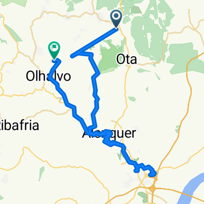
Overview
About this route
- 3 h 47 min
- Duration
- 54.3 km
- Distance
- 1,325 m
- Ascent
- 1,320 m
- Descent
- 14.4 km/h
- Avg. speed
- 337 m
- Max. altitude
Part of
Porto - Lisbon
7 stages
Continue with Bikemap
Use, edit, or download this cycling route
You would like to ride Ventosa - Almargem or customize it for your own trip? Here is what you can do with this Bikemap route:
Free features
- Save this route as favorite or in collections
- Copy & plan your own version of this route
- Sync your route with Garmin or Wahoo
Premium features
Free trial for 3 days, or one-time payment. More about Bikemap Premium.
- Navigate this route on iOS & Android
- Export a GPX / KML file of this route
- Create your custom printout (try it for free)
- Download this route for offline navigation
Discover more Premium features.
Get Bikemap PremiumFrom our community
Other popular routes starting in Ventosa
 Road to Sevilla
- Distance
- 839.6 km
- Ascent
- 1,704 m
- Descent
- 1,959 m
- Location
- Ventosa, Lisbon District, Portugal
 SARTIM-ASSALTO-MTJ
- Distance
- 41.3 km
- Ascent
- 1,323 m
- Descent
- 1,327 m
- Location
- Ventosa, Lisbon District, Portugal
 Rua das Eiras, Abrigada to Rua 13 de Janeiro 38, Cadaval
- Distance
- 34.8 km
- Ascent
- 1,240 m
- Descent
- 1,174 m
- Location
- Ventosa, Lisbon District, Portugal
 39.070° N -9.083° W a 39.059° N -9.006° W
- Distance
- 8.6 km
- Ascent
- 44 m
- Descent
- 104 m
- Location
- Ventosa, Lisbon District, Portugal
 Montejunto - Ataque por Pragança
- Distance
- 67.8 km
- Ascent
- 1,003 m
- Descent
- 1,000 m
- Location
- Ventosa, Lisbon District, Portugal
 montejunto
- Distance
- 58.6 km
- Ascent
- 902 m
- Descent
- 902 m
- Location
- Ventosa, Lisbon District, Portugal
 De N1 a Rua Francisco Correia
- Distance
- 43.2 km
- Ascent
- 587 m
- Descent
- 655 m
- Location
- Ventosa, Lisbon District, Portugal
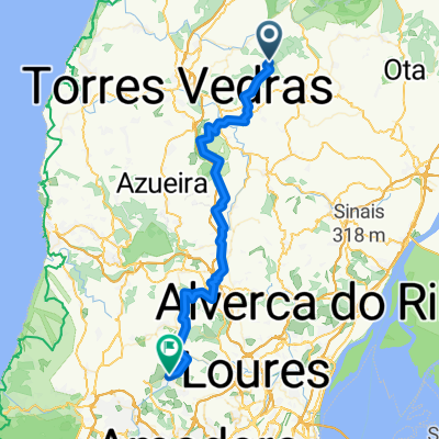 Ventosa - Almargem
- Distance
- 54.3 km
- Ascent
- 1,325 m
- Descent
- 1,320 m
- Location
- Ventosa, Lisbon District, Portugal
Open it in the app