

Von Wien bis München
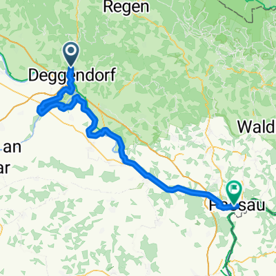
Deggendorf - Tegernheim
A cycling route starting in Deggendorf, Bavaria, Germany.
Overview
About this route
- 4 h 42 min
- Duration
- 83.3 km
- Distance
- 155 m
- Ascent
- 132 m
- Descent
- 17.8 km/h
- Avg. speed
- 342 m
- Max. altitude
Part of
Von Wien bis München
8 stages
Route quality
Waytypes & surfaces along the route
Waytypes
Quiet road
33.3 km
(40 %)
Path
18.3 km
(22 %)
Surfaces
Paved
75 km
(90 %)
Unpaved
2.5 km
(3 %)
Asphalt
75 km
(90 %)
Loose gravel
2.5 km
(3 %)
Undefined
5.8 km
(7 %)
Continue with Bikemap
Use, edit, or download this cycling route
You would like to ride Deggendorf - Tegernheim or customize it for your own trip? Here is what you can do with this Bikemap route:
Free features
- Save this route as favorite or in collections
- Copy & plan your own version of this route
- Split it into stages to create a multi-day tour
- Sync your route with Garmin or Wahoo
Premium features
Free trial for 3 days, or one-time payment. More about Bikemap Premium.
- Navigate this route on iOS & Android
- Export a GPX / KML file of this route
- Create your custom printout (try it for free)
- Download this route for offline navigation
Discover more Premium features.
Get Bikemap PremiumFrom our community
Other popular routes starting in Deggendorf
 Vilshofen an der Donau - Wörth an der Donau + Wörth an der Donau - Regensburg
- Distance
- 84 km
- Ascent
- 162 m
- Descent
- 129 m
- Location
- Deggendorf, Bavaria, Germany
 Winzer - Atzesberg
- Distance
- 58.5 km
- Ascent
- 149 m
- Descent
- 166 m
- Location
- Deggendorf, Bavaria, Germany
 W-07_Deggendorf-Passau_89km
- Distance
- 88.9 km
- Ascent
- 194 m
- Descent
- 208 m
- Location
- Deggendorf, Bavaria, Germany
 Offenberg - Schärding
- Distance
- 59 km
- Ascent
- 145 m
- Descent
- 152 m
- Location
- Deggendorf, Bavaria, Germany
 From Deggendorf to Landshut
- Distance
- 85.9 km
- Ascent
- 437 m
- Descent
- 360 m
- Location
- Deggendorf, Bavaria, Germany
 Von Deggendorf bis Melnik
- Distance
- 522.8 km
- Ascent
- 7,355 m
- Descent
- 7,507 m
- Location
- Deggendorf, Bavaria, Germany
 Ruseltour
- Distance
- 60.3 km
- Ascent
- 928 m
- Descent
- 928 m
- Location
- Deggendorf, Bavaria, Germany
 From Deggendorf to Landshut
- Distance
- 85.9 km
- Ascent
- 437 m
- Descent
- 360 m
- Location
- Deggendorf, Bavaria, Germany
Open it in the app