

Tour depuis Aiserey
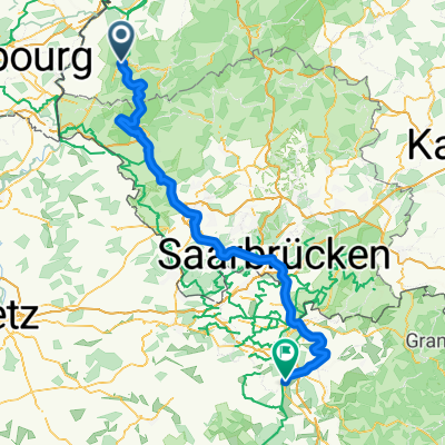
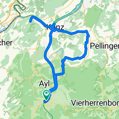
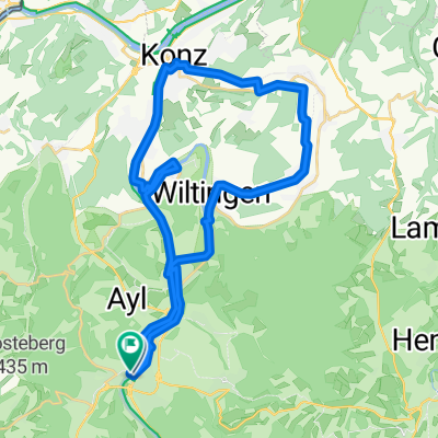
De Saarburg à Sarrelouis
A cycling route starting in Saarburg, Rhineland-Palatinate, Germany.
Overview
About this route
- 3 h 40 min
- Duration
- 57.2 km
- Distance
- 882 m
- Ascent
- 920 m
- Descent
- 15.6 km/h
- Avg. speed
- 244 m
- Max. altitude

Part of
Tour depuis Aiserey
16 stages
Route quality
Waytypes & surfaces along the route
Waytypes
Path
30.9 km
(54 %)
Quiet road
8 km
(14 %)
Surfaces
Paved
46.9 km
(82 %)
Unpaved
9.1 km
(16 %)
Asphalt
28.6 km
(50 %)
Paved (undefined)
10.9 km
(19 %)
Continue with Bikemap
Use, edit, or download this cycling route
You would like to ride De Saarburg à Sarrelouis or customize it for your own trip? Here is what you can do with this Bikemap route:
Free features
- Save this route as favorite or in collections
- Copy & plan your own version of this route
- Sync your route with Garmin or Wahoo
Premium features
Free trial for 3 days, or one-time payment. More about Bikemap Premium.
- Navigate this route on iOS & Android
- Export a GPX / KML file of this route
- Create your custom printout (try it for free)
- Download this route for offline navigation
Discover more Premium features.
Get Bikemap PremiumFrom our community
Other popular routes starting in Saarburg
 Route von Saarburg
- Distance
- 49.2 km
- Ascent
- 667 m
- Descent
- 666 m
- Location
- Saarburg, Rhineland-Palatinate, Germany
 Verano 26 . 06
- Distance
- 122.9 km
- Ascent
- 1,220 m
- Descent
- 1,175 m
- Location
- Saarburg, Rhineland-Palatinate, Germany
 Matthäus-Merian-Straße nach Blümchesfeld
- Distance
- 23.2 km
- Ascent
- 485 m
- Descent
- 478 m
- Location
- Saarburg, Rhineland-Palatinate, Germany
 RT 55km Saarb.-Konz-Rehlingen-Mannebach-Ayl-Saarb.
- Distance
- 54.9 km
- Ascent
- 630 m
- Descent
- 629 m
- Location
- Saarburg, Rhineland-Palatinate, Germany
 Mountainbike-Tour
- Distance
- 72.3 km
- Ascent
- 744 m
- Descent
- 749 m
- Location
- Saarburg, Rhineland-Palatinate, Germany
 Runde von Saarburg durch das Konzer Tälchen zur Albachmühle
- Distance
- 42.6 km
- Ascent
- 289 m
- Descent
- 291 m
- Location
- Saarburg, Rhineland-Palatinate, Germany
 van Saarburg via de oude Saar arm naar Konz
- Distance
- 34.4 km
- Ascent
- 258 m
- Descent
- 257 m
- Location
- Saarburg, Rhineland-Palatinate, Germany
 Von Saarburg bis Salmtal
- Distance
- 56.1 km
- Ascent
- 497 m
- Descent
- 458 m
- Location
- Saarburg, Rhineland-Palatinate, Germany
Open it in the app