

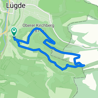
Lügde, Hagen, Sonneborn, Grießem, Bad Pyrmont
A cycling route starting in Lügde, North Rhine-Westphalia, Germany.
Overview
About this route
Good route, who’s joining?
- -:--
- Duration
- 32.1 km
- Distance
- 342 m
- Ascent
- 352 m
- Descent
- ---
- Avg. speed
- 279 m
- Max. altitude

Route quality
Waytypes & surfaces along the route
Waytypes
Quiet road
4.2 km
(13 %)
Path
3.9 km
(12 %)
Surfaces
Paved
26 km
(81 %)
Unpaved
1.3 km
(4 %)
Asphalt
25 km
(78 %)
Gravel
1.3 km
(4 %)
Continue with Bikemap
Use, edit, or download this cycling route
You would like to ride Lügde, Hagen, Sonneborn, Grießem, Bad Pyrmont or customize it for your own trip? Here is what you can do with this Bikemap route:
Free features
- Save this route as favorite or in collections
- Copy & plan your own version of this route
- Sync your route with Garmin or Wahoo
Premium features
Free trial for 3 days, or one-time payment. More about Bikemap Premium.
- Navigate this route on iOS & Android
- Export a GPX / KML file of this route
- Create your custom printout (try it for free)
- Download this route for offline navigation
Discover more Premium features.
Get Bikemap PremiumFrom our community
Other popular routes starting in Lügde
 Lügde Köterberg
- Distance
- 19.6 km
- Ascent
- 311 m
- Descent
- 51 m
- Location
- Lügde, North Rhine-Westphalia, Germany
 3.Mai 2013
- Distance
- 35.1 km
- Ascent
- 534 m
- Descent
- 535 m
- Location
- Lügde, North Rhine-Westphalia, Germany
 Herlingsburg - Nähe Schiedersee
- Distance
- 6.4 km
- Ascent
- 273 m
- Descent
- 272 m
- Location
- Lügde, North Rhine-Westphalia, Germany
 Der Kirchbergweg (Bad Pyrmont)
- Distance
- 7.3 km
- Ascent
- 240 m
- Descent
- 240 m
- Location
- Lügde, North Rhine-Westphalia, Germany
 Schieder Schwalenberg - Hameln Hbf
- Distance
- 35.2 km
- Ascent
- 60 m
- Descent
- 111 m
- Location
- Lügde, North Rhine-Westphalia, Germany
 Pyrmont_Hochebene_Köterberg
- Distance
- 51.6 km
- Ascent
- 574 m
- Descent
- 573 m
- Location
- Lügde, North Rhine-Westphalia, Germany
 15.06.2014
- Distance
- 91.1 km
- Ascent
- 380 m
- Descent
- 380 m
- Location
- Lügde, North Rhine-Westphalia, Germany
 Lügde, Hagen, Sonneborn, Grießem, Bad Pyrmont
- Distance
- 32.1 km
- Ascent
- 342 m
- Descent
- 352 m
- Location
- Lügde, North Rhine-Westphalia, Germany
Open it in the app