
Fischers Abenteuer 2026
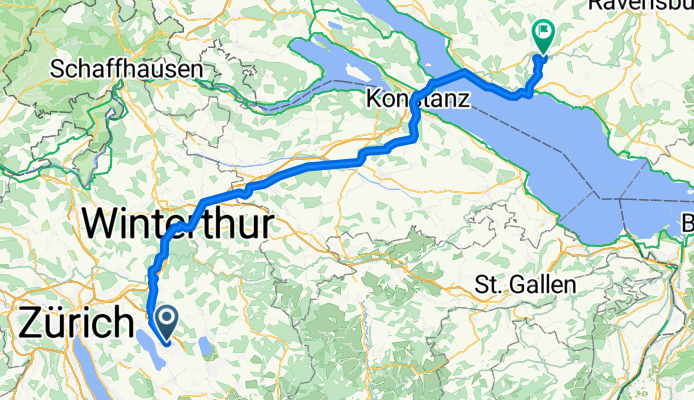
D1: Uster - Markdorf
A cycling route starting in Uster / Gschwader, Canton of Zurich, Switzerland.
Overview
About this route
Accommodation: Wirthshof GmbH Steibensteg 10 88677 Markdorf
- 5 h 37 min
- Duration
- 96.4 km
- Distance
- 857 m
- Ascent
- 882 m
- Descent
- 17.2 km/h
- Avg. speed
- 575 m
- Max. altitude

Part of
Fischers Abenteuer 2026
15 stages
Route quality
Waytypes & surfaces along the route
Waytypes
Quiet road
32.8 km
(34 %)
Path
22.2 km
(23 %)
Surfaces
Paved
85.8 km
(89 %)
Unpaved
1.9 km
(2 %)
Asphalt
84.9 km
(88 %)
Gravel
1.9 km
(2 %)
Continue with Bikemap
Use, edit, or download this cycling route
You would like to ride D1: Uster - Markdorf or customize it for your own trip? Here is what you can do with this Bikemap route:
Free features
- Save this route as favorite or in collections
- Copy & plan your own version of this route
- Split it into stages to create a multi-day tour
- Sync your route with Garmin or Wahoo
Premium features
Free trial for 3 days, or one-time payment. More about Bikemap Premium.
- Navigate this route on iOS & Android
- Export a GPX / KML file of this route
- Create your custom printout (try it for free)
- Download this route for offline navigation
Discover more Premium features.
Get Bikemap PremiumFrom our community
Other popular routes starting in Uster / Gschwader
 atzmänning-rickenpass
- Distance
- 99.3 km
- Ascent
- 1,094 m
- Descent
- 1,094 m
- Location
- Uster / Gschwader, Canton of Zurich, Switzerland
 Toggenburg (Girenbad+Hulftegg+Ghöch)
- Distance
- 92.3 km
- Ascent
- 1,202 m
- Descent
- 1,203 m
- Location
- Uster / Gschwader, Canton of Zurich, Switzerland
 Tösstaler
- Distance
- 69.1 km
- Ascent
- 776 m
- Descent
- 776 m
- Location
- Uster / Gschwader, Canton of Zurich, Switzerland
 Uster-Stoffel-Bauma-Tösstal-Diemberg-Jona
- Distance
- 54.2 km
- Ascent
- 723 m
- Descent
- 760 m
- Location
- Uster / Gschwader, Canton of Zurich, Switzerland
 Easter ride 96km - +690m
- Distance
- 96 km
- Ascent
- 625 m
- Descent
- 625 m
- Location
- Uster / Gschwader, Canton of Zurich, Switzerland
 Tablat-Sternenberg-Göch, 67 Km
- Distance
- 66.7 km
- Ascent
- 903 m
- Descent
- 901 m
- Location
- Uster / Gschwader, Canton of Zurich, Switzerland
 schwägalp von uster via hulftegg
- Distance
- 147.8 km
- Ascent
- 1,694 m
- Descent
- 1,694 m
- Location
- Uster / Gschwader, Canton of Zurich, Switzerland
 Route zu Denner
- Distance
- 15.6 km
- Ascent
- 68 m
- Descent
- 84 m
- Location
- Uster / Gschwader, Canton of Zurich, Switzerland
Open it in the app