
Fischers Abenteuer 2026
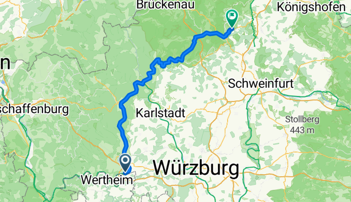
D6: Holzkirchen - Nüdlingen
A cycling route starting in Holzkirchen, Bavaria, Germany.
Overview
About this route
- 5 h 26 min
- Duration
- 94.8 km
- Distance
- 1,018 m
- Ascent
- 902 m
- Descent
- 17.4 km/h
- Avg. speed
- 351 m
- Max. altitude

Part of
Fischers Abenteuer 2026
15 stages
Route quality
Waytypes & surfaces along the route
Waytypes
Track
34.1 km
(36 %)
Cycleway
21.8 km
(23 %)
Surfaces
Paved
85.4 km
(90 %)
Unpaved
4.7 km
(5 %)
Asphalt
72.1 km
(76 %)
Paved (undefined)
12.3 km
(13 %)
Continue with Bikemap
Use, edit, or download this cycling route
You would like to ride D6: Holzkirchen - Nüdlingen or customize it for your own trip? Here is what you can do with this Bikemap route:
Free features
- Save this route as favorite or in collections
- Copy & plan your own version of this route
- Split it into stages to create a multi-day tour
- Sync your route with Garmin or Wahoo
Premium features
Free trial for 3 days, or one-time payment. More about Bikemap Premium.
- Navigate this route on iOS & Android
- Export a GPX / KML file of this route
- Create your custom printout (try it for free)
- Download this route for offline navigation
Discover more Premium features.
Get Bikemap PremiumFrom our community
Other popular routes starting in Holzkirchen
 Radltour2015_Etappe5c
- Distance
- 32.2 km
- Ascent
- 215 m
- Descent
- 223 m
- Location
- Holzkirchen, Bavaria, Germany
 D6: Holzkirchen - Nüdlingen
- Distance
- 94.8 km
- Ascent
- 1,018 m
- Descent
- 902 m
- Location
- Holzkirchen, Bavaria, Germany
 Main Gaubahn Taubertal Main
- Distance
- 216.7 km
- Ascent
- 1,084 m
- Descent
- 1,079 m
- Location
- Holzkirchen, Bavaria, Germany
 Homburg am Main nach Poppenhausen Wasserkuppe
- Distance
- 125.5 km
- Ascent
- 1,753 m
- Descent
- 1,282 m
- Location
- Holzkirchen, Bavaria, Germany
 Von Erlenbach über Trennfeld nach Wertheim und zurück
- Distance
- 34 km
- Ascent
- 71 m
- Descent
- 26 m
- Location
- Holzkirchen, Bavaria, Germany
 Homburg am Main, Marktheidenfeld, Kreuzwertheim (43,4 km)
- Distance
- 43.3 km
- Ascent
- 530 m
- Descent
- 532 m
- Location
- Holzkirchen, Bavaria, Germany
 St2299, Triefenstein nach Oskar-Popp-Straße 2, Kist
- Distance
- 26.4 km
- Ascent
- 352 m
- Descent
- 178 m
- Location
- Holzkirchen, Bavaria, Germany
 In den Wiesen 8, Triefenstein nach Eichholzstraße 17, Esselbach
- Distance
- 10.4 km
- Ascent
- 472 m
- Descent
- 290 m
- Location
- Holzkirchen, Bavaria, Germany
Open it in the app