mont chauve
- 20.6 km
- 702 m
- 703 m
- Saint-André-de-la-Roche, Provence-Alpes-Côte d'Azur Region, France
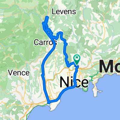
A cycling route starting in Saint-André-de-la-Roche, Provence-Alpes-Côte d'Azur Region, France.
Overview
Embark on a thrilling cycling adventure that takes you through scenic landscapes and varied terrains. The route is a 20.2-kilometer journey with a gentle ascent of 702 meters and a matching descent, ensuring a smooth ride throughout. The maximum elevation reaches a commendable 841 meters, offering breathtaking views at the highest point. Enjoy the thrill of cycling while exploring diverse surfaces, with a mix of paved and unpaved paths, perfect for those seeking both challenge and beauty.
AI generated
created this 23 days ago
Route quality
Quiet road
10.9 km
(53 %)
Road
9.7 km
(47 %)
Paved
19.9 km
(97 %)
Asphalt
19.9 km
(97 %)
Undefined
0.6 km
(3 %)
Continue with Bikemap
You would like to ride mont chauve or customize it for your own trip? Here is what you can do with this Bikemap route:
Free trial for 3 days, or one-time payment. More about Bikemap Premium.
Discover more Premium features.
Get Bikemap PremiumFrom our community
Open it in the app