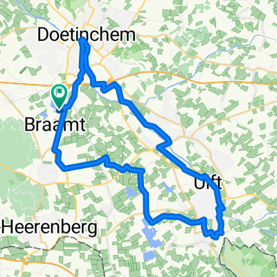
- 48.5 km
- 100 m
- 101 m
- Doetinchem, Gelderland, The Netherlands
Raadhuisstraat, Doetinchem naar J D Pennekampweg, Hummelo
A cycling route starting in Doetinchem, Gelderland, The Netherlands.
Overview
About this route
Start in a local park and follow the paved path through lush greenery. The route begins with a gentle incline of 10 meters, winding through peaceful trails and alongside quiet streams. After a few kilometers, the path becomes more challenging with a 6-meter descent. The final stretch features a gradual climb to a maximum elevation of 17 meters, offering rewarding views. The entire route is smooth and suitable for all skill levels.
AI generated
- 21 min
- Duration
- 6.8 km
- Distance
- 11 m
- Ascent
- 6 m
- Descent
- 19.8 km/h
- Avg. speed
- 18 m
- Max. altitude
created this 23 days ago
Route quality
Waytypes & surfaces along the route
Waytypes
Quiet road
4.5 km
(67 %)
Cycleway
2 km
(29 %)
Surfaces
Paved
3.9 km
(57 %)
Asphalt
3.9 km
(57 %)
Undefined
2.9 km
(43 %)
Continue with Bikemap
Use, edit, or download this cycling route
You would like to ride Raadhuisstraat, Doetinchem naar J D Pennekampweg, Hummelo or customize it for your own trip? Here is what you can do with this Bikemap route:
Free features
- Save this route as favorite or in collections
- Copy & plan your own version of this route
- Sync your route with Garmin or Wahoo
Premium features
Free trial for 3 days, or one-time payment. More about Bikemap Premium.
- Navigate this route on iOS & Android
- Export a GPX / KML file of this route
- Create your custom printout (try it for free)
- Download this route for offline navigation
Discover more Premium features.
Get Bikemap PremiumFrom our community
Other popular routes starting in Doetinchem
- Kruisbergen lang
- Raadhuisstraat, Doetinchem naar J D Pennekampweg, Hummelo
- 6.8 km
- 11 m
- 6 m
- Doetinchem, Gelderland, The Netherlands
- Met de fiets de route van de Halve marathon van Doetinchem
- 21.2 km
- 3 m
- 7 m
- Doetinchem, Gelderland, The Netherlands
- Landweerswal, Braamt nach Landweerswal, Braamt
- 37.1 km
- 13 m
- 13 m
- Doetinchem, Gelderland, The Netherlands
- Rondje Doesburg
- 50.9 km
- 30 m
- 30 m
- Doetinchem, Gelderland, The Netherlands
- route 1 met bike map
- 76.7 km
- 38 m
- 37 m
- Doetinchem, Gelderland, The Netherlands
- Hummeloën
- 30.7 km
- 78 m
- 81 m
- Doetinchem, Gelderland, The Netherlands
- Von Braamt bis Rees
- 23 km
- 62 m
- 60 m
- Doetinchem, Gelderland, The Netherlands
Open it in the app


