

16.04.2025 07:45:11
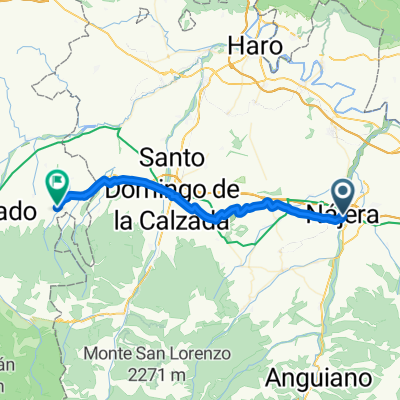
A cycling route starting in Nájera, La Rioja, Spain.
Overview
About this route
- 6 h 32 min
- Duration
- 99.1 km
- Distance
- 1,250 m
- Ascent
- 1,297 m
- Descent
- 15.2 km/h
- Avg. speed
- 657 m
- Max. altitude

Continue with Bikemap
Use, edit, or download this cycling route
You would like to ride 16.04.2025 07:45:11 or customize it for your own trip? Here is what you can do with this Bikemap route:
Free features
- Save this route as favorite or in collections
- Copy & plan your own version of this route
- Split it into stages to create a multi-day tour
- Sync your route with Garmin or Wahoo
Premium features
Free trial for 3 days, or one-time payment. More about Bikemap Premium.
- Navigate this route on iOS & Android
- Export a GPX / KML file of this route
- Create your custom printout (try it for free)
- Download this route for offline navigation
Discover more Premium features.
Get Bikemap PremiumFrom our community
Other popular routes starting in Nájera
 Najera - Pradoluengo
- Distance
- 154.7 km
- Ascent
- 3,064 m
- Descent
- 2,607 m
- Location
- Nájera, La Rioja, Spain
 NAJERA - VILORIA DE RIOJA
- Distance
- 37 km
- Ascent
- 521 m
- Descent
- 208 m
- Location
- Nájera, La Rioja, Spain
 2011 Santiago 3.dan (Najera - Ages)
- Distance
- 70.8 km
- Ascent
- 818 m
- Descent
- 347 m
- Location
- Nájera, La Rioja, Spain
 Long bike tour from Nájera to Belorado
- Distance
- 63.4 km
- Ascent
- 590 m
- Descent
- 303 m
- Location
- Nájera, La Rioja, Spain
 Nájera 1
- Distance
- 129 km
- Ascent
- 1,465 m
- Descent
- 1,485 m
- Location
- Nájera, La Rioja, Spain
 Camino day 4
- Distance
- 54.9 km
- Ascent
- 805 m
- Descent
- 354 m
- Location
- Nájera, La Rioja, Spain
 Falkenfels Bühlertal 3. Etappe: Najera_Santo Domingo de Silos
- Distance
- 144.5 km
- Ascent
- 3,392 m
- Descent
- 2,870 m
- Location
- Nájera, La Rioja, Spain
 Camino Day 4
- Distance
- 66.8 km
- Ascent
- 944 m
- Descent
- 487 m
- Location
- Nájera, La Rioja, Spain
Open it in the app