
Calle Río Gargáligas, Малага до Calle Río Gargáligas, Малага
- 15.9 km
- 85 m
- 46 m
- Málaga, Andalusia, Spain
A cycling route starting in Málaga, Andalusia, Spain.
Overview
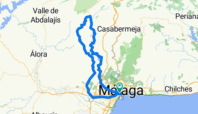
Moderate trip around lake Casasola towards majestic formation El Torcal and back. Any 90 km with views over valleys Barranco del Sol and Hoya de Malaga.From main square take street Calle Cisneros, turn right and then left across the bridge Aurora. All the time keep straight through streets Marmoles / M. Maldonado / Av. de C. Haya / Lope de Vega untill Puerto de la Torre. Then follow signs for Almogia, road A-7075.This A-7075 will lead you along lake Casasola to Villanueva de la Concepción through long and narrow valley Barranco del Sol. Steady 15 km long climb is impressive and finally appears huge massif of El Torcal. There will be strong climb to Villanueva. In the village turn left for Almogia through MA-3403. There you can enjoy views over N. P. Montes de Malaga on the left or Sierra del Valle del Abdalajis and even Sierra de las Nieves on the right. After 2 km turn right to undergo last steep section and then fastly down to village Los Nunez. Leave village, cross the bridge and on crossroad slightly turn right for Campanillas, road MA-415, later A-7058.From Campanillas just easily follow signs for Malaga again. - Moderate trip around lake Casasola towards majestic formation El Torcal and back. Any 90 km with views over valleys Barranco del Sol and Hoya de Malaga.From main square take street Calle Cisneros, turn right and then left across the bridge Aurora. All the time keep straight through streets Marmoles / M. Maldonado / Av. de C. Haya / Lope de Vega untill Puerto de la Torre. Then follow signs for Almogia, road A-7075.This A-7075 will lead you along lake Casasola to Villanueva de la Concepción through long and narrow valley Barranco del Sol. Steady 15 km long climb is impressive and finally appears huge massif of El Torcal. There will be strong climb to Villanueva. In the village turn left for Almogia through MA-3403. There you can enjoy views over N. P. Montes de Malaga on the left or Sierra del Valle del Abdalajis and even Sierra de las Nieves on the right. After 2 km turn right to undergo last steep section and then fastly down to village Los Nunez. Leave village, cross the bridge and on crossroad slightly turn right for Campanillas, road MA-415, later A-7058.From Campanillas just easily follow signs for Malaga again.
created this 24 days ago
Continue with Bikemap
You would like to ride RB-09 Malaga-PTO. Torre-Villanueva Concepcion-Almogia-Los Nunez-Campanillas-Malaga or customize it for your own trip? Here is what you can do with this Bikemap route:
Free trial for 3 days, or one-time payment. More about Bikemap Premium.
Discover more Premium features.
Get Bikemap PremiumFrom our community
Open it in the app