

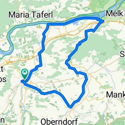
Wieselburg - Wastl - Erlaufboden - Wieselburg
A cycling route starting in Petzenkirchen, Lower Austria, Austria.
Overview
About this route
Wieselburg B25 to Neubruck; then B28 through Puchenstuben; up or down by Wastl; B20 towards Mariazell; in Reith, turn right onto Panoramastrasse; detour at Sulzbichl; back on Panoramastrasse; passing by Trefflingtalerhaus; in Puchenstuben refresh at Kräuterhäusl; after Neubruck, turn right onto B25; cross the Erlauf at Neustift; back to Wieselburg via Scheibbs and Purgstall (on the bike path);
- -:--
- Duration
- 104.3 km
- Distance
- 1,460 m
- Ascent
- 1,461 m
- Descent
- ---
- Avg. speed
- ---
- Max. altitude

Route quality
Waytypes & surfaces along the route
Waytypes
Quiet road
27.1 km
(26 %)
Road
10.4 km
(10 %)
Surfaces
Paved
94.9 km
(91 %)
Unpaved
4.2 km
(4 %)
Asphalt
82.4 km
(79 %)
Paved (undefined)
12.5 km
(12 %)
Continue with Bikemap
Use, edit, or download this cycling route
You would like to ride Wieselburg - Wastl - Erlaufboden - Wieselburg or customize it for your own trip? Here is what you can do with this Bikemap route:
Free features
- Save this route as favorite or in collections
- Copy & plan your own version of this route
- Split it into stages to create a multi-day tour
- Sync your route with Garmin or Wahoo
Premium features
Free trial for 3 days, or one-time payment. More about Bikemap Premium.
- Navigate this route on iOS & Android
- Export a GPX / KML file of this route
- Create your custom printout (try it for free)
- Download this route for offline navigation
Discover more Premium features.
Get Bikemap PremiumFrom our community
Other popular routes starting in Petzenkirchen
 Wildpark Hochrieß
- Distance
- 7.5 km
- Ascent
- 59 m
- Descent
- 20 m
- Location
- Petzenkirchen, Lower Austria, Austria
 Wieselburg Großa Hochriess Purgstall Runde
- Distance
- 20.5 km
- Ascent
- 228 m
- Descent
- 228 m
- Location
- Petzenkirchen, Lower Austria, Austria
 Kendl - Pöchlarn
- Distance
- 8.6 km
- Ascent
- 20 m
- Descent
- 60 m
- Location
- Petzenkirchen, Lower Austria, Austria
 Schöllenbach - Plankenstein - Luft - Pöchlarn - Sarling
- Distance
- 93.7 km
- Ascent
- 1,642 m
- Descent
- 1,657 m
- Location
- Petzenkirchen, Lower Austria, Austria
 Ybbs-Erlauf- Donau - Melk - Tal Runde Sep, 22
- Distance
- 212.8 km
- Ascent
- 2,581 m
- Descent
- 2,584 m
- Location
- Petzenkirchen, Lower Austria, Austria
 Annatsberg - Frankenfels - Annatsberg
- Distance
- 77.1 km
- Ascent
- 809 m
- Descent
- 809 m
- Location
- Petzenkirchen, Lower Austria, Austria
 W-Diesendorf-Melk(Kraftwerk)-pöchlarn-w
- Distance
- 53.2 km
- Ascent
- 213 m
- Descent
- 212 m
- Location
- Petzenkirchen, Lower Austria, Austria
 Schöllenbach - Ybbs - Viehdorf - Kollmitzberg - Freienstein - Ybbs - Schöllenbach
- Distance
- 70.4 km
- Ascent
- 605 m
- Descent
- 605 m
- Location
- Petzenkirchen, Lower Austria, Austria
Open it in the app