

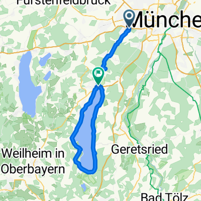
Gräfelfing - Mittenwald - Mit Zug zurück
A cycling route starting in Gräfelfing, Bavaria, Germany.
Overview
About this route
Nette Tagesstrecke, gute Kondition nötig.
Bis Kochelsee (Campingplatz Renken/Kesselberg) kaum nennenswerte Anstiege.<br /><br />Kochelsee bis Walchensee entweder über die Straße oder über den Jacobsweg (teilweise sehr steil, felsig und lockeres Gestein)
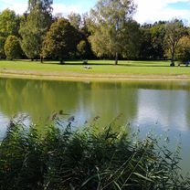
Östlich um den Walchensee war es am schönsten. Bei Temperaturen um die 30 Grad waren sämtliche Wiesen, Strände und vorstehende Felsen mit Sonnenanbetern belegt.<br />über ca. 1000 Meter nahmen nur Skytesurfer den Felsstrand ein.
Bis nach Wallgau sind die Fahrradwege dürftig ausgebaut. Nach dem Anstieg vom Kochelsee zum Walchensee war der stetige Anstieg nach Wallgau anstrengend.<br /><br />Wallgau bis Mittenwald immer wieder kurze Anstiege. Die Fahrradwege hören plötzlich auf und man muss sich manchmal erst zurechtfinden oder entlang der Landstraße, bis man wieder auf einem Fahradweg trifft.<br /><br />Von Mittenwald mit dem Zug zurück.<br /><br />Start Morgens: 8:00 Uhr<br />Zug Mittenwald nach München: 19:37
- -:--
- Duration
- 107.9 km
- Distance
- 566 m
- Ascent
- 198 m
- Descent
- ---
- Avg. speed
- ---
- Max. altitude

Route quality
Waytypes & surfaces along the route
Waytypes
Track
37.1 km
(34 %)
Quiet road
29.8 km
(28 %)
Surfaces
Paved
67.3 km
(62 %)
Unpaved
32.8 km
(30 %)
Asphalt
64.5 km
(60 %)
Gravel
22.6 km
(21 %)
Continue with Bikemap
Use, edit, or download this cycling route
You would like to ride Gräfelfing - Mittenwald - Mit Zug zurück or customize it for your own trip? Here is what you can do with this Bikemap route:
Free features
- Save this route as favorite or in collections
- Copy & plan your own version of this route
- Split it into stages to create a multi-day tour
- Sync your route with Garmin or Wahoo
Premium features
Free trial for 3 days, or one-time payment. More about Bikemap Premium.
- Navigate this route on iOS & Android
- Export a GPX / KML file of this route
- Create your custom printout (try it for free)
- Download this route for offline navigation
Discover more Premium features.
Get Bikemap PremiumFrom our community
Other popular routes starting in Gräfelfing
 Von Gräfelfing bis Pasing
- Distance
- 4.3 km
- Ascent
- 0 m
- Descent
- 17 m
- Location
- Gräfelfing, Bavaria, Germany
 Am Vogelherd, Gräfelfing - Ammerland, Münsing
- Distance
- 32.1 km
- Ascent
- 318 m
- Descent
- 262 m
- Location
- Gräfelfing, Bavaria, Germany
 Germeringer See September 27 2020
- Distance
- 30.6 km
- Ascent
- 137 m
- Descent
- 141 m
- Location
- Gräfelfing, Bavaria, Germany
 Hirschgarten Nymphenburg Teufelsberg
- Distance
- 25.1 km
- Ascent
- 65 m
- Descent
- 65 m
- Location
- Gräfelfing, Bavaria, Germany
 Trainingsstrecke (mittel) etwa 50 km
- Distance
- 55.2 km
- Ascent
- 204 m
- Descent
- 204 m
- Location
- Gräfelfing, Bavaria, Germany
 Starnberger
- Distance
- 69.3 km
- Ascent
- 239 m
- Descent
- 182 m
- Location
- Gräfelfing, Bavaria, Germany
 Gräfelfing - Mittenwald - Mit Zug zurück
- Distance
- 107.9 km
- Ascent
- 566 m
- Descent
- 198 m
- Location
- Gräfelfing, Bavaria, Germany
 Mittagsrunde
- Distance
- 30 km
- Ascent
- 142 m
- Descent
- 140 m
- Location
- Gräfelfing, Bavaria, Germany
Open it in the app