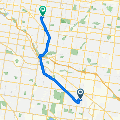
Clayton Rd, Clayton to Nepean Hwy, Moorabbin
- 10.6 km
- 43 m
- 72 m
- Clayton, Victoria, Australia
A cycling route starting in Clayton, Victoria, Australia.
Overview
Embark on a scenic 10.4 km cycling adventure through rolling countryside trails, with a gentle ascent of 28 meters and a moderate descent of 72 meters. The route reaches its highest point at 80 meters, offering stunning views along the way. This path is well-maintained with a mix of paved and unpaved surfaces, making it ideal for cyclists looking to enjoy both nature and exercise.
AI generated
created this 9 days ago
Route quality
Quiet road
6.3 km
(58 %)
Cycleway
1.3 km
(12 %)
Paved
7.9 km
(73 %)
Unpaved
1.1 km
(10 %)
Paved (undefined)
5.2 km
(48 %)
Asphalt
2.3 km
(21 %)
Continue with Bikemap
You would like to ride Haughton Rd, Oakleigh to Nepean Hwy, Moorabbin or customize it for your own trip? Here is what you can do with this Bikemap route:
Free trial for 3 days, or one-time payment. More about Bikemap Premium.
Discover more Premium features.
Get Bikemap PremiumFrom our community
Open it in the app