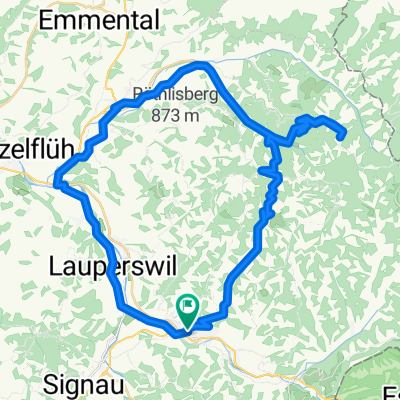
- 31.1 km
- 897 m
- 903 m
- Langnau, Canton of Bern, Switzerland
Langnau i.E. - Luzern (Etappe 4)
A cycling route starting in Langnau, Canton of Bern, Switzerland.
Overview
About this route
- -:--
- Duration
- 82.9 km
- Distance
- 719 m
- Ascent
- 949 m
- Descent
- ---
- Avg. speed
- 939 m
- Max. altitude
created this 16 years ago
Route quality
Waytypes & surfaces along the route
Waytypes
Road
17.4 km
(21 %)
Quiet road
17.4 km
(21 %)
Surfaces
Paved
52.2 km
(63 %)
Unpaved
4.1 km
(5 %)
Asphalt
50.6 km
(61 %)
Gravel
4.1 km
(5 %)
Route highlights
Points of interest along the route
Point of interest after 23 km
<table style="width:auto;"><tr><td><a href="http://picasaweb.google.ch/lh/photo/eCpmY3Z-lQ8bDw9EhLYBKg?authkey=Gv1sRgCJPk15CGqf_RyAE&feat=embedwebsite"><img src="http://lh6.ggpht.com/_bn58IXyYB5w/SivlTZhJTOI/AAAAAAAAE84/-vYzPM-6xMU/s400/DSCN3120.JPG" /></a></td></tr><tr><td style="font-family:arial,sans-serif; font-size:11px; text-align:right">Von <a href="http://picasaweb.google.ch/Bernhard.Tinner/2009060305VelotourGlaubenbergEmmental?authkey=Gv1sRgCJPk15CGqf_RyAE&feat=embedwebsite">2009.06.03-05 Velotour Glaubenberg Emmental</a></td></tr></table>
Continue with Bikemap
Use, edit, or download this cycling route
You would like to ride Langnau i.E. - Luzern (Etappe 4) or customize it for your own trip? Here is what you can do with this Bikemap route:
Free features
- Save this route as favorite or in collections
- Copy & plan your own version of this route
- Split it into stages to create a multi-day tour
- Sync your route with Garmin or Wahoo
Premium features
Free trial for 3 days, or one-time payment. More about Bikemap Premium.
- Navigate this route on iOS & Android
- Export a GPX / KML file of this route
- Create your custom printout (try it for free)
- Download this route for offline navigation
Discover more Premium features.
Get Bikemap PremiumFrom our community
Other popular routes starting in Langnau
- Chuderhüsi
- Bäraustrasse 71A nach Bäraustrasse 71A
- 9.2 km
- 41 m
- 107 m
- Langnau, Canton of Bern, Switzerland
- Di - Route in Langnau im Emmental
- 51.4 km
- 1,682 m
- 1,682 m
- Langnau, Canton of Bern, Switzerland
- Von Langnau im Emmental bis Laupen
- 56.8 km
- 794 m
- 983 m
- Langnau, Canton of Bern, Switzerland
- C60+ Langnau - Blapbach - Truebschachen - Burgdorf
- 51.2 km
- 619 m
- 775 m
- Langnau, Canton of Bern, Switzerland
- Neue Gibelrunde
- 8.4 km
- 165 m
- 172 m
- Langnau, Canton of Bern, Switzerland
- Lüderenalp-Runde
- 43.3 km
- 1,178 m
- 1,177 m
- Langnau, Canton of Bern, Switzerland
- Langnau-Howacht-Blapbach-Rämmisgummen
- 36.1 km
- 771 m
- 773 m
- Langnau, Canton of Bern, Switzerland
Open it in the app


