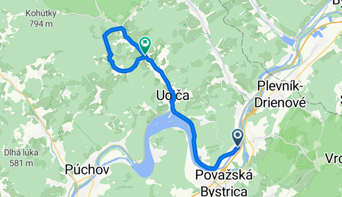
Považské Podhradie-Mariková-Stražisko-P.Podhradie 36km
A cycling route starting in Považská Bystrica, Trenčiansky kraj, Slovak Republic.
Overview
About this route
- -:--
- Duration
- 20.4 km
- Distance
- 323 m
- Ascent
- 290 m
- Descent
- ---
- Avg. speed
- ---
- Avg. speed
Route quality
Waytypes & surfaces along the route
Waytypes
Road
7 km
(34 %)
Busy road
6.2 km
(30 %)
Surfaces
Paved
13.2 km
(64 %)
Asphalt
13.2 km
(64 %)
Undefined
7.3 km
(36 %)
Route highlights
Points of interest along the route
Point of interest after 13.7 km
Point of interest after 15.4 km
Point of interest after 17 km
Point of interest after 17.2 km
Continue with Bikemap
Use, edit, or download this cycling route
You would like to ride Považské Podhradie-Mariková-Stražisko-P.Podhradie 36km or customize it for your own trip? Here is what you can do with this Bikemap route:
Free features
- Save this route as favorite or in collections
- Copy & plan your own version of this route
- Sync your route with Garmin or Wahoo
Premium features
Free trial for 3 days, or one-time payment. More about Bikemap Premium.
- Navigate this route on iOS & Android
- Export a GPX / KML file of this route
- Create your custom printout (try it for free)
- Download this route for offline navigation
Discover more Premium features.
Get Bikemap PremiumFrom our community
Other popular routes starting in Považská Bystrica
- Budzogáň_2016_5
- Distance
- 45.2 km
- Ascent
- 1,713 m
- Descent
- 1,720 m
- Location
- Považská Bystrica, Trenčiansky kraj, Slovak Republic
- Považská Bystrica - Bytča
- Distance
- 17 km
- Ascent
- 61 m
- Descent
- 53 m
- Location
- Považská Bystrica, Trenčiansky kraj, Slovak Republic
- Považská Bystrica- D. Lieskov- Mojtín
- Distance
- 22.3 km
- Ascent
- 566 m
- Descent
- 239 m
- Location
- Považská Bystrica, Trenčiansky kraj, Slovak Republic
- Považ. Bystrica- Manín. Tiesňava- Podmanín
- Distance
- 17 km
- Ascent
- 324 m
- Descent
- 326 m
- Location
- Považská Bystrica, Trenčiansky kraj, Slovak Republic
- Zliechov-Čičmany-Rajecká Lesná
- Distance
- 74.2 km
- Ascent
- 771 m
- Descent
- 789 m
- Location
- Považská Bystrica, Trenčiansky kraj, Slovak Republic
- manin, sulov
- Distance
- 26.7 km
- Ascent
- 699 m
- Descent
- 686 m
- Location
- Považská Bystrica, Trenčiansky kraj, Slovak Republic
- Považská Bystrica - Manín - Vrchteplá
- Distance
- 12.8 km
- Ascent
- 305 m
- Descent
- 87 m
- Location
- Považská Bystrica, Trenčiansky kraj, Slovak Republic
- Považská Bystrica- Udiča- Púchov
- Distance
- 16.5 km
- Ascent
- 71 m
- Descent
- 102 m
- Location
- Považská Bystrica, Trenčiansky kraj, Slovak Republic
Open it in the app