Savoy OLC Belgrave force cycle paths
- 71.6 km
- 687 m
- 494 m
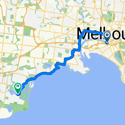
- Docklands, Victoria, Australia
A cycling route starting in Docklands, Victoria, Australia.
Overview
Start your cycling adventure at 630 Little Collins St, Melbourne, VIC, and make your way to Brompton Junction, where the ride begins along 819 Nicholson St, Brunswick East. The route takes you through Melbourne's vibrant cycling network. The bike network here is 89.4% paved, with 91.2% of the ride on cycleways.
As you progress, you'll find 58.7% of the route is on asphalt, and 30.7% on concrete. The elevation climbs steadily, with a maximum elevation of 241 meters. You will ascend 558 meters and descend 332 meters throughout the journey.
The scenery will offer you plenty of opportunities to enjoy Melbourne's urban landscape, with occasional glimpses of the city skyline.
AI generated
created this 16 days ago
Route quality
Cycleway
70.2 km
(98 %)
Road
0.7 km
(1 %)
Access road
0.7 km
(1 %)
Paved
62.3 km
(87 %)
Unpaved
2.1 km
(3 %)
Asphalt
43.7 km
(61 %)
Concrete
16.5 km
(23 %)
Continue with Bikemap
You would like to ride Savoy OLC Belgrave force cycle paths or customize it for your own trip? Here is what you can do with this Bikemap route:
Free trial for 3 days, or one-time payment. More about Bikemap Premium.
Discover more Premium features.
Get Bikemap PremiumFrom our community
Open it in the app