Massanassa-Dos Aguas-Bicorp-Massanassa
- 161.3 km
- 2,865 m
- 2,862 m
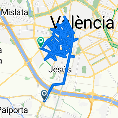
- Benetússer, Valencia, Spain
A cycling route starting in Benetússer, Valencia, Spain.
Overview
Discover the scenic beauty of this 54.4 km cycling adventure, perfect for both beginners and experienced riders. This route offers a balanced mix of gentle climbs and descents, with an elevation gain and drop of just 118 meters each way, making it accessible for all levels. The path ascends to a maximum elevation of 30 meters, providing a rewarding challenge without overwhelming effort. Enjoy the smooth, paved surface that ensures a comfortable ride. Whether you're exploring the area for leisure or looking to test your cycling skills, this route promises an enjoyable and scenic journey.
AI generated
created this 5 days ago
Route quality
Quiet road
24.1 km
(44 %)
Cycleway
5.5 km
(10 %)
Paved
36.7 km
(67 %)
Asphalt
35.1 km
(64 %)
Paved (undefined)
1.6 km
(3 %)
Undefined
18.1 km
(33 %)
Continue with Bikemap
You would like to ride brno antonio or customize it for your own trip? Here is what you can do with this Bikemap route:
Free trial for 3 days, or one-time payment. More about Bikemap Premium.
Discover more Premium features.
Get Bikemap PremiumFrom our community
Open it in the app