Rakousko 2012-1.den-14.7.So
A cycling route starting in Reichenthal, Upper Austria, Austria.
Overview
About this route
1.den - 14.7.2012 sobota
-
Summerau - (1. příhraniční stanice - sem platí lístek českých drah) - Reichenthal - Schenkenfelden - po R5
-
U Habrucku se napojujeme na R28
-
Reichenau (bereme pitnou vodu a začneme pomalu hledat nocleh
-
vjíždíme do semknutého údolí s říčkou GroSe Gusen, podle které sjíždíme stále dolů
-
nocleh nacházíme tak 10m nad silnicí, na nepoužívané lesní cestě
Summerau - Niederreichenthal - Reichenthal - Kamplmühle - Schenkenfelden - Steischild-Siedlung - Zeil - Ramberg - Reichenau im Mühlkreis - Gusen - Gusental - Hirschstein - Rinzendorf
- -:--
- Duration
- 30.2 km
- Distance
- 293 m
- Ascent
- 471 m
- Descent
- ---
- Avg. speed
- ---
- Max. altitude
Route quality
Waytypes & surfaces along the route
Waytypes
Road
27.9 km
(92 %)
Quiet road
1.7 km
(6 %)
Surfaces
Paved
28 km
(93 %)
Unpaved
0.2 km
(<1 %)
Asphalt
28 km
(93 %)
Ground
0.2 km
(<1 %)
Undefined
2.1 km
(7 %)
Route highlights
Points of interest along the route
Point of interest after 7.8 km
Cesta deseti mlýnů - http://www.vyletyrakousko.cz/ausflugstipp/2603783/cesta_deseti_mlynu_

Photo after 7.8 km
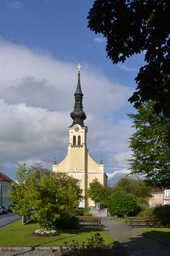
REICHENTHAL - Farní kostel s kazatelnou 7 smrtelných hříchů

Photo after 29.7 km
1.nocleh (hezky na kopečku nad silnicí)
Continue with Bikemap
Use, edit, or download this cycling route
You would like to ride Rakousko 2012-1.den-14.7.So or customize it for your own trip? Here is what you can do with this Bikemap route:
Free features
- Save this route as favorite or in collections
- Copy & plan your own version of this route
- Sync your route with Garmin or Wahoo
Premium features
Free trial for 3 days, or one-time payment. More about Bikemap Premium.
- Navigate this route on iOS & Android
- Export a GPX / KML file of this route
- Create your custom printout (try it for free)
- Download this route for offline navigation
Discover more Premium features.
Get Bikemap PremiumFrom our community
Other popular routes starting in Reichenthal
 Zofin
Zofin- Distance
- 69 km
- Ascent
- 1,157 m
- Descent
- 1,130 m
- Location
- Reichenthal, Upper Austria, Austria
 summerau-bad radkersburg
- Distance
- 411.9 km
- Ascent
- 4,513 m
- Descent
- 4,967 m
- Location
- Reichenthal, Upper Austria, Austria
 Reichenthal Wullowitz- Paßberg- Rainbach- Reichenthal
- Distance
- 68.6 km
- Ascent
- 674 m
- Descent
- 674 m
- Location
- Reichenthal, Upper Austria, Austria
 Summerau - Mauthausen
- Distance
- 49.2 km
- Ascent
- 509 m
- Descent
- 931 m
- Location
- Reichenthal, Upper Austria, Austria
 Grenzlandtour - Leopoldschlag - CZ - Wullowitz
- Distance
- 35.1 km
- Ascent
- 395 m
- Descent
- 395 m
- Location
- Reichenthal, Upper Austria, Austria
 Mühlviertler Kernlandrunde
- Distance
- 28.2 km
- Ascent
- 455 m
- Descent
- 458 m
- Location
- Reichenthal, Upper Austria, Austria
 Reichenthal - Linz
- Distance
- 42.4 km
- Ascent
- 625 m
- Descent
- 1,026 m
- Location
- Reichenthal, Upper Austria, Austria
 Rakousko 2012-1.den-14.7.So
- Distance
- 30.2 km
- Ascent
- 293 m
- Descent
- 471 m
- Location
- Reichenthal, Upper Austria, Austria
Open it in the app


