
Große Mairunde
A cycling route starting in Veitsbronn, Bavaria, Germany.
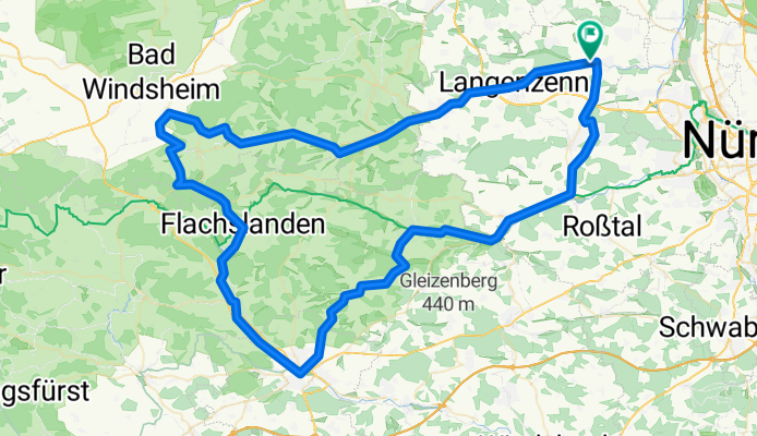
Overview
About this route
A tour for the ambitious trekking cyclist. As some sections run along gravel paths, the tour is not suitable for road cyclists.
The route connects parts of the Biberttalradweg, Dietenhofenradweg, and Zenntalradweg. There are a few challenging climbs, but the cyclist is also rewarded with corresponding descents.
Most of the time, the route runs on bike paths and lightly trafficked side roads. You ride through some very picturesque villages and can enjoy beautiful natural scenery.
There are always good opportunities to stop along the route or, if needed, change to the train.
- -:--
- Duration
- 110 km
- Distance
- 870 m
- Ascent
- 849 m
- Descent
- ---
- Avg. speed
- 515 m
- Max. altitude

Route quality
Waytypes & surfaces along the route
Waytypes
Quiet road
36.3 km
(33 %)
Track
23.1 km
(21 %)
Surfaces
Paved
71.5 km
(65 %)
Unpaved
7.7 km
(7 %)
Asphalt
67.1 km
(61 %)
Gravel
5.5 km
(5 %)
Continue with Bikemap
Use, edit, or download this cycling route
You would like to ride Große Mairunde or customize it for your own trip? Here is what you can do with this Bikemap route:
Free features
- Save this route as favorite or in collections
- Copy & plan your own version of this route
- Split it into stages to create a multi-day tour
- Sync your route with Garmin or Wahoo
Premium features
Free trial for 3 days, or one-time payment. More about Bikemap Premium.
- Navigate this route on iOS & Android
- Export a GPX / KML file of this route
- Create your custom printout (try it for free)
- Download this route for offline navigation
Discover more Premium features.
Get Bikemap PremiumFrom our community
Other popular routes starting in Veitsbronn
 Beschauliche Tour von Siegelsdorf zur Cadolzburg
- Distance
- 24.4 km
- Ascent
- 204 m
- Descent
- 197 m
- Location
- Veitsbronn, Bavaria, Germany
 MTB-Veitsbronn-Kanal-23km
- Distance
- 22.5 km
- Ascent
- 139 m
- Descent
- 139 m
- Location
- Veitsbronn, Bavaria, Germany
 Familientour zum Obernzenner See
- Distance
- 35.9 km
- Ascent
- 290 m
- Descent
- 232 m
- Location
- Veitsbronn, Bavaria, Germany
 Bhf. Siegelsdorf - Frickenhausen
- Distance
- 86.7 km
- Ascent
- 250 m
- Descent
- 358 m
- Location
- Veitsbronn, Bavaria, Germany
 Veitsbronn- Alte Hochstrasse - Laubendorf
- Distance
- 64.2 km
- Ascent
- 464 m
- Descent
- 463 m
- Location
- Veitsbronn, Bavaria, Germany
 Veitsbronn Cadolzburg Kirchfarrnbach
- Distance
- 50.9 km
- Ascent
- 439 m
- Descent
- 441 m
- Location
- Veitsbronn, Bavaria, Germany
 Kleine Runde über Bräuersdorf
- Distance
- 23.3 km
- Ascent
- 170 m
- Descent
- 177 m
- Location
- Veitsbronn, Bavaria, Germany
 Veitsbronn_42_km
- Distance
- 42.1 km
- Ascent
- 174 m
- Descent
- 175 m
- Location
- Veitsbronn, Bavaria, Germany
Open it in the app