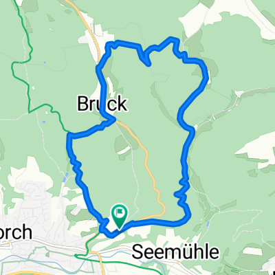
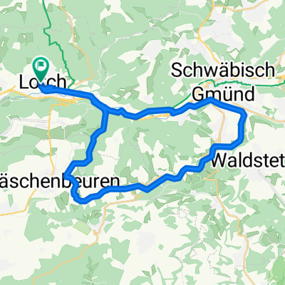
Lorch-Kaisersträßle-Schorndorf-Remsweg-Lorch
A cycling route starting in Lorch, Baden-Württemberg, Germany.
Overview
About this route
Flacher Start mit Anstieg im Wald zum Wäscherschlößle, Auf der Höhe über Rattenharz-Bruck-Kaiserstraßle, dann hinunter nach Schorndorf, über den schönen Marktplatz (mit Eisstopp oder Durstlöschhalt), dann am Remsufer eben zurück nach Lorch
- -:--
- Duration
- 41.1 km
- Distance
- 285 m
- Ascent
- 282 m
- Descent
- ---
- Avg. speed
- ---
- Avg. speed
Route quality
Waytypes & surfaces along the route
Waytypes
Quiet road
16.9 km
(41 %)
Track
9.7 km
(24 %)
Surfaces
Paved
32.6 km
(79 %)
Unpaved
4.7 km
(11 %)
Asphalt
31.4 km
(76 %)
Loose gravel
3.1 km
(8 %)
Continue with Bikemap
Use, edit, or download this cycling route
You would like to ride Lorch-Kaisersträßle-Schorndorf-Remsweg-Lorch or customize it for your own trip? Here is what you can do with this Bikemap route:
Free features
- Save this route as favorite or in collections
- Copy & plan your own version of this route
- Sync your route with Garmin or Wahoo
Premium features
Free trial for 3 days, or one-time payment. More about Bikemap Premium.
- Navigate this route on iOS & Android
- Export a GPX / KML file of this route
- Create your custom printout (try it for free)
- Download this route for offline navigation
Discover more Premium features.
Get Bikemap PremiumFrom our community
Other popular routes starting in Lorch
- Lorch/Haselbachtal-Fichtenberg Bhf.
- Distance
- 28.2 km
- Ascent
- 550 m
- Descent
- 496 m
- Location
- Lorch, Baden-Württemberg, Germany
- Lorch-Kleindeinbach-Wetzgau-Mutlangen-Alfdorf
- Distance
- 28.9 km
- Ascent
- 248 m
- Descent
- 248 m
- Location
- Lorch, Baden-Württemberg, Germany
- Lorch-Kaisersträßle-Schorndorf-Remsweg-Lorch
- Distance
- 41.1 km
- Ascent
- 285 m
- Descent
- 282 m
- Location
- Lorch, Baden-Württemberg, Germany
- Welzheim-Himmelreich-Wäschenbeuren
- Distance
- 77.3 km
- Ascent
- 743 m
- Descent
- 745 m
- Location
- Lorch, Baden-Württemberg, Germany
- Rundstrecke von Lorch
- Distance
- 86.3 km
- Ascent
- 1,269 m
- Descent
- 1,213 m
- Location
- Lorch, Baden-Württemberg, Germany
- Vier Täler Tour bei Welzheim
- Distance
- 51.3 km
- Ascent
- 427 m
- Descent
- 428 m
- Location
- Lorch, Baden-Württemberg, Germany
- Lorch-Haselbach
- Distance
- 18.6 km
- Ascent
- 291 m
- Descent
- 294 m
- Location
- Lorch, Baden-Württemberg, Germany
- gemuetliche Runde
- Distance
- 34.4 km
- Ascent
- 461 m
- Descent
- 492 m
- Location
- Lorch, Baden-Württemberg, Germany
Open it in the app