Határon-innen és túl
A cycling route starting in Senta, Vojvodina, Serbia.
Overview
About this route
The section between Kanizsa and Horgos puts a bit of strain on both the bike and the cyclist, especially where there are small trenches in the roadway. From Vásárhely, there is a short section of new bike path that is of very good quality, but there is a part on the main road 47 and 45 where unfortunately there is nothing, so care must be taken with the cars whizzing past.
- -:--
- Duration
- 151.8 km
- Distance
- 68 m
- Ascent
- 44 m
- Descent
- ---
- Avg. speed
- ---
- Max. altitude
Continue with Bikemap
Use, edit, or download this cycling route
You would like to ride Határon-innen és túl or customize it for your own trip? Here is what you can do with this Bikemap route:
Free features
- Save this route as favorite or in collections
- Copy & plan your own version of this route
- Split it into stages to create a multi-day tour
- Sync your route with Garmin or Wahoo
Premium features
Free trial for 3 days, or one-time payment. More about Bikemap Premium.
- Navigate this route on iOS & Android
- Export a GPX / KML file of this route
- Create your custom printout (try it for free)
- Download this route for offline navigation
Discover more Premium features.
Get Bikemap PremiumFrom our community
Other popular routes starting in Senta
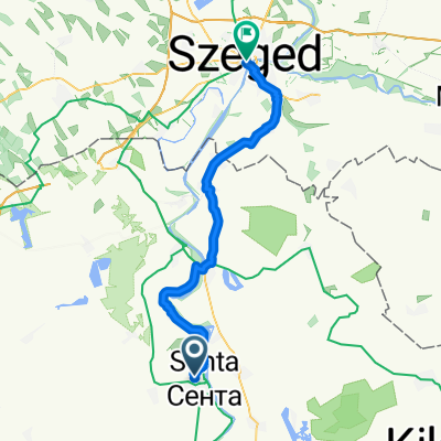
- Route to Széchenyi tér
- Distance
- 51.2 km
- Ascent
- 53 m
- Descent
- 47 m
- Location
- Senta, Vojvodina, Serbia
- Zenta-Herceg Novi
- Distance
- 643.9 km
- Ascent
- 4,158 m
- Descent
- 4,090 m
- Location
- Senta, Vojvodina, Serbia
- Sportos útvonal
- Distance
- 15 km
- Ascent
- 3 m
- Descent
- 50 m
- Location
- Senta, Vojvodina, Serbia
- Határon-innen és túl
- Distance
- 151.8 km
- Ascent
- 68 m
- Descent
- 44 m
- Location
- Senta, Vojvodina, Serbia
- senta sentes
- Distance
- 126.9 km
- Ascent
- 46 m
- Descent
- 42 m
- Location
- Senta, Vojvodina, Serbia
- Zenta-Nagykikinda
- Distance
- 46.7 km
- Ascent
- 15 m
- Descent
- 17 m
- Location
- Senta, Vojvodina, Serbia
- Relaxed route
- Distance
- 7.9 km
- Ascent
- 70 m
- Descent
- 69 m
- Location
- Senta, Vojvodina, Serbia
- Zenta - Szeged
- Distance
- 51.1 km
- Ascent
- 259 m
- Descent
- 259 m
- Location
- Senta, Vojvodina, Serbia
Open it in the app