

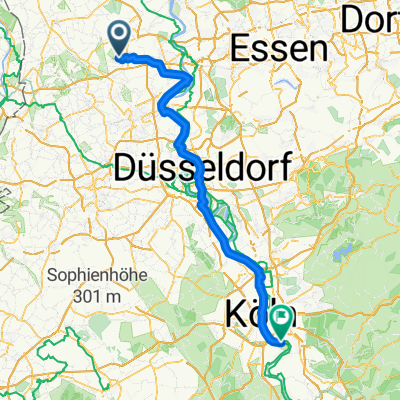
Rheurdt - Krickebecker Seen - Rheurdt
A cycling route starting in Rheurdt, North Rhine-Westphalia, Germany.
Overview
About this route
Trekking route, mostly asphalt, partly gravel, scenic
- -:--
- Duration
- 54.8 km
- Distance
- 135 m
- Ascent
- 135 m
- Descent
- ---
- Avg. speed
- ---
- Max. altitude
Continue with Bikemap
Use, edit, or download this cycling route
You would like to ride Rheurdt - Krickebecker Seen - Rheurdt or customize it for your own trip? Here is what you can do with this Bikemap route:
Free features
- Save this route as favorite or in collections
- Copy & plan your own version of this route
- Sync your route with Garmin or Wahoo
Premium features
Free trial for 3 days, or one-time payment. More about Bikemap Premium.
- Navigate this route on iOS & Android
- Export a GPX / KML file of this route
- Create your custom printout (try it for free)
- Download this route for offline navigation
Discover more Premium features.
Get Bikemap PremiumFrom our community
Other popular routes starting in Rheurdt
 Düsseldorf - Königswinter
- Distance
- 101.6 km
- Ascent
- 232 m
- Descent
- 221 m
- Location
- Rheurdt, North Rhine-Westphalia, Germany
 Aldekerk - Rheurdt - Vlyn - Aldekerk
- Distance
- 23.9 km
- Ascent
- 61 m
- Descent
- 62 m
- Location
- Rheurdt, North Rhine-Westphalia, Germany
 Entschleunigungstour 13
- Distance
- 11.5 km
- Ascent
- 83 m
- Descent
- 82 m
- Location
- Rheurdt, North Rhine-Westphalia, Germany
 22 km rund um Toenisberg
- Distance
- 22.2 km
- Ascent
- 80 m
- Descent
- 78 m
- Location
- Rheurdt, North Rhine-Westphalia, Germany
 niederrhein
- Distance
- 79.1 km
- Ascent
- 110 m
- Descent
- 118 m
- Location
- Rheurdt, North Rhine-Westphalia, Germany
 Durch den Vluynbusch
- Distance
- 12.5 km
- Ascent
- 29 m
- Descent
- 29 m
- Location
- Rheurdt, North Rhine-Westphalia, Germany
 Ina-Seidel-Straße 19, Neukirchen-Vluyn nach Ina-Seidel-Straße 27, Neukirchen-Vluyn
- Distance
- 44 km
- Ascent
- 180 m
- Descent
- 180 m
- Location
- Rheurdt, North Rhine-Westphalia, Germany
 Hiltruds Geburtstag
- Distance
- 19.2 km
- Ascent
- 13 m
- Descent
- 14 m
- Location
- Rheurdt, North Rhine-Westphalia, Germany
Open it in the app