

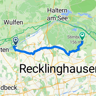
Route in Marl
A cycling route starting in Marl, North Rhine-Westphalia, Germany.
Overview
About this route
- 5 h 15 min
- Duration
- 92.2 km
- Distance
- 295 m
- Ascent
- 295 m
- Descent
- 17.6 km/h
- Avg. speed
- 81 m
- Max. altitude
mzxi

created this 16 days ago
Route quality
Waytypes & surfaces along the route
Waytypes
Path
62.7 km
(68 %)
Quiet road
25.8 km
(28 %)
Surfaces
Paved
73.7 km
(80 %)
Unpaved
2.8 km
(3 %)
Asphalt
59 km
(64 %)
Paved (undefined)
14.7 km
(16 %)
Continue with Bikemap
Use, edit, or download this cycling route
You would like to ride Route in Marl or customize it for your own trip? Here is what you can do with this Bikemap route:
Free features
- Save this route as favorite or in collections
- Copy & plan your own version of this route
- Split it into stages to create a multi-day tour
- Sync your route with Garmin or Wahoo
Premium features
Free trial for 3 days, or one-time payment. More about Bikemap Premium.
- Navigate this route on iOS & Android
- Export a GPX / KML file of this route
- Create your custom printout (try it for free)
- Download this route for offline navigation
Discover more Premium features.
Get Bikemap PremiumFrom our community
Other popular routes starting in Marl
- Zu den Mühlen, Marl nach Hülsstraße, Marl
- 12.2 km
- 58 m
- 39 m
- Marl, North Rhine-Westphalia, Germany
- Nordstraße nach Holthoffstraße 120C
- 30.4 km
- 226 m
- 238 m
- Marl, North Rhine-Westphalia, Germany
- Am Kanal nach In den Wellen
- 24.5 km
- 167 m
- 150 m
- Marl, North Rhine-Westphalia, Germany
- Meisenstraße 4, Marl nach Meisenstraße 2, Marl
- 12.8 km
- 62 m
- 59 m
- Marl, North Rhine-Westphalia, Germany
- Route in Marl
- 92.2 km
- 295 m
- 295 m
- Marl, North Rhine-Westphalia, Germany
Garmin
Marl Hüls - Zeche Fürst Leopold - Hervester Bruch- 41.8 km
- 267 m
- 269 m
- Marl, North Rhine-Westphalia, Germany
- Hohe Mark - Alle Steigungen
- 79.9 km
- 454 m
- 465 m
- Marl, North Rhine-Westphalia, Germany


Open it in the app