

Rakousko 2012-3.den-16.7.Po
A cycling route starting in Haidershofen, Lower Austria, Austria.
Overview
About this route
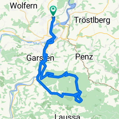
Stadtgut Steyr - Steyr - Garsten - Sand (vlak.zast.) - Lahrndorf - Dürnbach - Maireben - Ternberg - Trattenbach muzeum - Goldgrub - Losenstein (vlak.zast.) - Reichraming - branch from the Enns to the Reichraming river in Hintergebirge
- -:--
- Duration
- 42.6 km
- Distance
- 322 m
- Ascent
- 251 m
- Descent
- ---
- Avg. speed
- ---
- Max. altitude

Route quality
Waytypes & surfaces along the route
Waytypes
Quiet road
20 km
(47 %)
Road
17.9 km
(42 %)
Surfaces
Paved
15.8 km
(37 %)
Asphalt
15.8 km
(37 %)
Undefined
26.8 km
(63 %)
Route highlights
Points of interest along the route

Photo after 1.6 km
Schovka před deštěm a dalo by se tu i přespat

Photo after 7.3 km
Steyr

Photo after 8.5 km
Steyr

Photo after 9.1 km
obídek

Photo after 12.1 km
Garsten

Photo after 23.1 km
Ternberg

Photo after 25.5 km
Trattenbach...muzeum výroby těchto možů

Photo after 32.8 km
Losenstein

Photo after 38.8 km
Reichraming

Photo after 42.6 km
3.noc na parkovišti za Reichramingem
Continue with Bikemap
Use, edit, or download this cycling route
You would like to ride Rakousko 2012-3.den-16.7.Po or customize it for your own trip? Here is what you can do with this Bikemap route:
Free features
- Save this route as favorite or in collections
- Copy & plan your own version of this route
- Sync your route with Garmin or Wahoo
Premium features
Free trial for 3 days, or one-time payment. More about Bikemap Premium.
- Navigate this route on iOS & Android
- Export a GPX / KML file of this route
- Create your custom printout (try it for free)
- Download this route for offline navigation
Discover more Premium features.
Get Bikemap PremiumFrom our community
Other popular routes starting in Haidershofen
 DambergKriterium
- Distance
- 48 km
- Ascent
- 776 m
- Descent
- 776 m
- Location
- Haidershofen, Lower Austria, Austria
 Testrunde
- Distance
- 21.8 km
- Ascent
- 245 m
- Descent
- 238 m
- Location
- Haidershofen, Lower Austria, Austria
 Rakousko 2012-3.den-16.7.Po
- Distance
- 42.6 km
- Ascent
- 322 m
- Descent
- 251 m
- Location
- Haidershofen, Lower Austria, Austria
 Standardrunde Damberg
- Distance
- 28.6 km
- Ascent
- 762 m
- Descent
- 577 m
- Location
- Haidershofen, Lower Austria, Austria
 Überlandpartie-Ost
- Distance
- 32.3 km
- Ascent
- 327 m
- Descent
- 330 m
- Location
- Haidershofen, Lower Austria, Austria
 Sträußl - Kürnberg - Spadenberg - Damberg - Behamberg
- Distance
- 70 km
- Ascent
- 1,449 m
- Descent
- 1,449 m
- Location
- Haidershofen, Lower Austria, Austria
 Dietach - Kürnbergrunde
- Distance
- 50.2 km
- Ascent
- 886 m
- Descent
- 825 m
- Location
- Haidershofen, Lower Austria, Austria
 Wachtberg, Behamberg nach Zlapp und Hof, Heiligenblut am Großglockner
- Distance
- 317.3 km
- Ascent
- 7,411 m
- Descent
- 5,483 m
- Location
- Haidershofen, Lower Austria, Austria
Open it in the app