

Rakousko 2012-4.den-17.7.Út
A cycling route starting in Reichraming, Upper Austria, Austria.
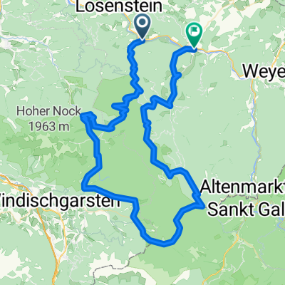
Overview
About this route
P1 - P2 - P3 - we turn off at GroSer Bach and ride on Hintergebirge R9 - Biwakplatz WeiSwasser - WeiSwasser - Mooshöhe - Langseitengütl - Unterlaussa - Stummer - Engl - Altenmarkt bei St. Gallen - Goltl - turn behind the transformer station towards the edge of the pasture for overnight stay
- -:--
- Duration
- 42.2 km
- Distance
- 686 m
- Ascent
- 594 m
- Descent
- ---
- Avg. speed
- ---
- Max. altitude

Route quality
Waytypes & surfaces along the route
Waytypes
Track
18.2 km
(43 %)
Quiet road
6.3 km
(15 %)
Surfaces
Paved
16.1 km
(38 %)
Unpaved
19.4 km
(46 %)
Gravel
15.6 km
(37 %)
Asphalt
15.2 km
(36 %)
Route highlights
Points of interest along the route

Photo after 2 km
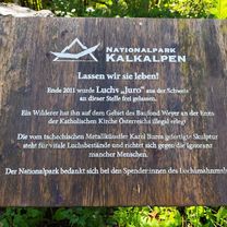
Začátek Reichraminger Hintergebirge

Photo after 9.6 km
Lesníků občerstvovna

Photo after 16.7 km
Tábořiště na Hintergebirge

Photo after 21.1 km
Konečně nahoře sedlo Mooshöhe

Photo after 26.1 km
Oddych u kostela

Photo after 36.7 km
Oddych u kostela a schovka před deštěm

Photo after 41.8 km
4. nocleh na kraji louky kousek od silnice
Continue with Bikemap
Use, edit, or download this cycling route
You would like to ride Rakousko 2012-4.den-17.7.Út or customize it for your own trip? Here is what you can do with this Bikemap route:
Free features
- Save this route as favorite or in collections
- Copy & plan your own version of this route
- Sync your route with Garmin or Wahoo
Premium features
Free trial for 3 days, or one-time payment. More about Bikemap Premium.
- Navigate this route on iOS & Android
- Export a GPX / KML file of this route
- Create your custom printout (try it for free)
- Download this route for offline navigation
Discover more Premium features.
Get Bikemap PremiumFrom our community
Other popular routes starting in Reichraming
 Reichraming zu den Schleierfällen
- Distance
- 20.2 km
- Ascent
- 558 m
- Descent
- 299 m
- Location
- Reichraming, Upper Austria, Austria
 Hintergebirgsradweg R9 Reichraming
- Distance
- 45.5 km
- Ascent
- 640 m
- Descent
- 664 m
- Location
- Reichraming, Upper Austria, Austria
 2020-09-05 4:02
- Distance
- 58.3 km
- Ascent
- 1,227 m
- Descent
- 1,229 m
- Location
- Reichraming, Upper Austria, Austria
 Reichraming R9
- Distance
- 41.3 km
- Ascent
- 537 m
- Descent
- 521 m
- Location
- Reichraming, Upper Austria, Austria
 Breitenau, Ebenforstalm, Breitenau
- Distance
- 24.2 km
- Ascent
- 690 m
- Descent
- 683 m
- Location
- Reichraming, Upper Austria, Austria
 Anlaufalm
- Distance
- 53.5 km
- Ascent
- 871 m
- Descent
- 875 m
- Location
- Reichraming, Upper Austria, Austria
 Reichraming Hintergebirge Anlaufalm
- Distance
- 47.7 km
- Ascent
- 2,264 m
- Descent
- 2,263 m
- Location
- Reichraming, Upper Austria, Austria
 Reichraming Ramble
- Distance
- 95.2 km
- Ascent
- 3,869 m
- Descent
- 3,842 m
- Location
- Reichraming, Upper Austria, Austria
Open it in the app