

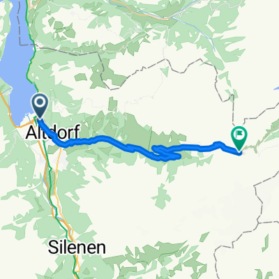
CH07_Rund um den Vierwaldstätter See
A cycling route starting in Flüelen, Canton of Uri, Switzerland.
Overview
About this route
Wonderful ride around Lake Lucerne. Starting in Flüelen at the train station (parking available). Then always along the lake shore. Constantly new impressions of this beautiful lake landscape. Opportunities to refuel and relax in the small villages come up time and again. A slight ascent behind Küsstnacht to Udligenswil (but can be skipped and continue along the lake) from Adligenswil, it then goes with racing speed down to Lucerne. The rest of the route until just before Buochs is a bit dull. From here, the last meters go along the lake to Beckenried. Now there's a relaxing ride left (there's no possibility to return this way by bike) a cozy ferry ride back to Flüelen, where one can wonderfully recover from the exertions.
- -:--
- Duration
- 73.6 km
- Distance
- 620 m
- Ascent
- 625 m
- Descent
- ---
- Avg. speed
- ---
- Max. altitude
Continue with Bikemap
Use, edit, or download this cycling route
You would like to ride CH07_Rund um den Vierwaldstätter See or customize it for your own trip? Here is what you can do with this Bikemap route:
Free features
- Save this route as favorite or in collections
- Copy & plan your own version of this route
- Sync your route with Garmin or Wahoo
Premium features
Free trial for 3 days, or one-time payment. More about Bikemap Premium.
- Navigate this route on iOS & Android
- Export a GPX / KML file of this route
- Create your custom printout (try it for free)
- Download this route for offline navigation
Discover more Premium features.
Get Bikemap PremiumFrom our community
Other popular routes starting in Flüelen
 CH07_Rund um den Vierwaldstätter See
- Distance
- 73.6 km
- Ascent
- 620 m
- Descent
- 625 m
- Location
- Flüelen, Canton of Uri, Switzerland
 Vierwaldstättersee
- Distance
- 51.4 km
- Ascent
- 940 m
- Descent
- 932 m
- Location
- Flüelen, Canton of Uri, Switzerland
 Klausenpass Westseite
- Distance
- 26.8 km
- Ascent
- 1,626 m
- Descent
- 101 m
- Location
- Flüelen, Canton of Uri, Switzerland
 Fluelen -Gotthard Pass Faido National Route 3
- Distance
- 82.7 km
- Ascent
- 1,687 m
- Descent
- 1,382 m
- Location
- Flüelen, Canton of Uri, Switzerland
 Flüelen_Camping-Golzernsee_Rundtour
- Distance
- 61.1 km
- Ascent
- 0 m
- Descent
- 0 m
- Location
- Flüelen, Canton of Uri, Switzerland
 2016 6 Trier - Gotthardpass
- Distance
- 50.8 km
- Ascent
- 1,681 m
- Descent
- 35 m
- Location
- Flüelen, Canton of Uri, Switzerland
 Fluen to Erstfeld
- Distance
- 12 km
- Ascent
- 66 m
- Descent
- 27 m
- Location
- Flüelen, Canton of Uri, Switzerland
 jgjgh
jgjgh- Distance
- 206.2 km
- Ascent
- 5,980 m
- Descent
- 4,656 m
- Location
- Flüelen, Canton of Uri, Switzerland
Open it in the app