

Doliną Prądnika
A cycling route starting in Sąspów, Lesser Poland Voivodeship, Poland.
Overview
About this route
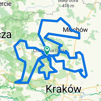
Trasa z pod zamku w Pieskowej Skale.
Jest to pętla Doliną Prądnika biegnąca dalej przez Zamek Korzkiew oraz drogę nr 794 do Skały.
Odcinek początkowy jest bardzo przyjemny.
Droga biegnie ciągle w dół.
Na wysokości Prądnika Korzkiewskiego odbiliśmy niebieskimi znakami na wschód.
Tutaj pierwszy wypych :-)
Jedziemy do końca niebieskim szlakiem i dalej dość męczący pagórkowaty odcinek ruchliwą drogą do Skały.
Ze Skały wracamy drogą nr 773 do Pieskowej Skały czyli miejsca naszego startu.
- -:--
- Duration
- 32.4 km
- Distance
- 360 m
- Ascent
- 360 m
- Descent
- ---
- Avg. speed
- ---
- Max. altitude
Route quality
Waytypes & surfaces along the route
Waytypes
Busy road
19.4 km
(60 %)
Quiet road
6.2 km
(19 %)
Surfaces
Paved
28.3 km
(87 %)
Unpaved
1.6 km
(5 %)
Asphalt
28.3 km
(87 %)
Gravel
1.6 km
(5 %)
Continue with Bikemap
Use, edit, or download this cycling route
You would like to ride Doliną Prądnika or customize it for your own trip? Here is what you can do with this Bikemap route:
Free features
- Save this route as favorite or in collections
- Copy & plan your own version of this route
- Sync your route with Garmin or Wahoo
Premium features
Free trial for 3 days, or one-time payment. More about Bikemap Premium.
- Navigate this route on iOS & Android
- Export a GPX / KML file of this route
- Create your custom printout (try it for free)
- Download this route for offline navigation
Discover more Premium features.
Get Bikemap PremiumFrom our community
Other popular routes starting in Sąspów
 Pieskowa Skała Kolna
- Distance
- 35.9 km
- Ascent
- 247 m
- Descent
- 448 m
- Location
- Sąspów, Lesser Poland Voivodeship, Poland
 OPN - JR
- Distance
- 47.9 km
- Ascent
- 600 m
- Descent
- 596 m
- Location
- Sąspów, Lesser Poland Voivodeship, Poland
 Skarbami Jury Krakowsko-Częstochowskiej
- Distance
- 46.7 km
- Ascent
- 587 m
- Descent
- 581 m
- Location
- Sąspów, Lesser Poland Voivodeship, Poland
 Sąspów
- Distance
- 22.8 km
- Ascent
- 342 m
- Descent
- 342 m
- Location
- Sąspów, Lesser Poland Voivodeship, Poland
 Doliną Prądnika
- Distance
- 32.4 km
- Ascent
- 360 m
- Descent
- 360 m
- Location
- Sąspów, Lesser Poland Voivodeship, Poland
 Droga Gminna do 297, Wielmoża
- Distance
- 11.9 km
- Ascent
- 156 m
- Descent
- 169 m
- Location
- Sąspów, Lesser Poland Voivodeship, Poland
 Okolice Skały
- Distance
- 323 km
- Ascent
- 1,377 m
- Descent
- 1,371 m
- Location
- Sąspów, Lesser Poland Voivodeship, Poland
 Piesza 4 - Ojcowski Park Narodowy
- Distance
- 21.8 km
- Ascent
- 507 m
- Descent
- 608 m
- Location
- Sąspów, Lesser Poland Voivodeship, Poland
Open it in the app