

ZU DEN BÖHMISCHEN FREUNDEN: Hohenwarth - Eck - Arbersee - Zelezna Ruda - Nyrsko - Rittsteig - Ottenzell - Hohenwarth
A cycling route starting in Hohenwarth, Bavaria, Germany.
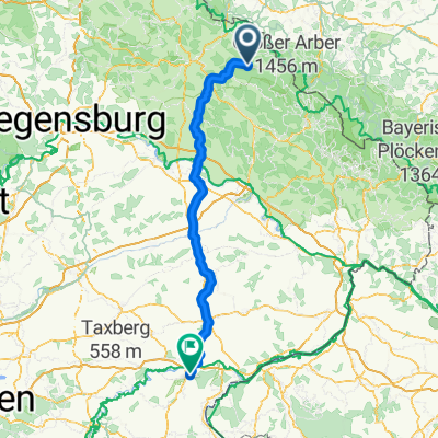
Overview
About this route
Start Hohenwarth
On Lamer Straße ST2138 towards Arrach
After Arrach turn right onto Eckstraße
Direction Arnbruck
Through Arnbruck towards Blachendorf
Continue towards Oberried to Unterried
After Unterried turn left towards Mais
Continue on Kötztinger Straße to Bodenmais
Continue on Arberseestraße to Arbersee
Bypass Arbersee heading towards Brennes
At Brennes turn right onto Brennesstraße towards Bayerisch Eisenstein
In Bayerisch Eisenstein turn left towards Zelezna Ruda
Continue on the 190 towards Hojsova Straz
Continue to Zelena Lhota
Continue left past the lake to Stara Lhota
Continue to Nyrsko - turn left to Uhliste
Continue to Svata Katerina
Continue towards Rittsteig - Neurittsteig
Continue on Zollstraße to Buchetbühl
Continue to Engelshütt
In Engelshütt turn right to Haibühl
Continue to Ottenzell - Stadlern
Continue to the destination at Hohenwarth
- -:--
- Duration
- 103 km
- Distance
- 1,603 m
- Ascent
- 1,603 m
- Descent
- ---
- Avg. speed
- ---
- Max. altitude
Route quality
Waytypes & surfaces along the route
Waytypes
Quiet road
22.7 km
(22 %)
Road
9.3 km
(9 %)
Surfaces
Paved
72.1 km
(70 %)
Unpaved
1 km
(1 %)
Asphalt
72.1 km
(70 %)
Gravel
1 km
(1 %)
Undefined
29.9 km
(29 %)
Continue with Bikemap
Use, edit, or download this cycling route
You would like to ride ZU DEN BÖHMISCHEN FREUNDEN: Hohenwarth - Eck - Arbersee - Zelezna Ruda - Nyrsko - Rittsteig - Ottenzell - Hohenwarth or customize it for your own trip? Here is what you can do with this Bikemap route:
Free features
- Save this route as favorite or in collections
- Copy & plan your own version of this route
- Split it into stages to create a multi-day tour
- Sync your route with Garmin or Wahoo
Premium features
Free trial for 3 days, or one-time payment. More about Bikemap Premium.
- Navigate this route on iOS & Android
- Export a GPX / KML file of this route
- Create your custom printout (try it for free)
- Download this route for offline navigation
Discover more Premium features.
Get Bikemap PremiumFrom our community
Other popular routes starting in Hohenwarth
 ZU DEN BÖHMISCHEN FREUNDEN: Hohenwarth - Eck - Arbersee - Zelezna Ruda - Nyrsko - Rittsteig - Ottenzell - Hohenwarth
- Distance
- 100 km
- Ascent
- 1,646 m
- Descent
- 1,646 m
- Location
- Hohenwarth, Bavaria, Germany
 ZU DEN BÖHMISCHEN FREUNDEN: Hohenwarth - Eck - Arbersee - Zelezna Ruda - Nyrsko - Rittsteig - Ottenzell - Hohenwarth
- Distance
- 103 km
- Ascent
- 1,603 m
- Descent
- 1,603 m
- Location
- Hohenwarth, Bavaria, Germany
 Gotzendorf 25, Hohenwarth nach Gotzendorf 25, Hohenwarth
- Distance
- 22.6 km
- Ascent
- 1,018 m
- Descent
- 767 m
- Location
- Hohenwarth, Bavaria, Germany
 Höllhöhe - Osser Rundtour
- Distance
- 30.4 km
- Ascent
- 972 m
- Descent
- 972 m
- Location
- Hohenwarth, Bavaria, Germany
 Äåˆ?? nach Äåˆ??
- Distance
- 25 km
- Ascent
- 140 m
- Descent
- 270 m
- Location
- Hohenwarth, Bavaria, Germany
 Kötztinger Hütte
- Distance
- 3.3 km
- Ascent
- 519 m
- Descent
- 6 m
- Location
- Hohenwarth, Bavaria, Germany
 Runde übers Eckstein
- Distance
- 26 km
- Ascent
- 904 m
- Descent
- 891 m
- Location
- Hohenwarth, Bavaria, Germany
 ¿ã nach ¿ã
- Distance
- 147.8 km
- Ascent
- 850 m
- Descent
- 950 m
- Location
- Hohenwarth, Bavaria, Germany
Open it in the app