

Rakousko 2012-9.den-22.7.Ne
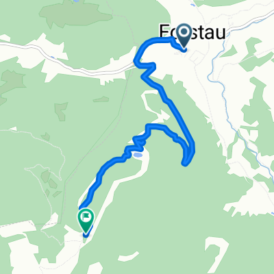
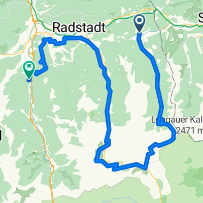
A cycling route starting in Forstau, Salzburg, Austria.
Overview
About this route
Radstadt - Altenmarkt im Pongau - Eben im Pongau - Hüttau - Pöham - Bischofshofen - Mitterberghütten - Maschl - Sankt Johann Pongau - Plankenau - gorge Lichtensteinklamm and back - Schwarzach im Pongau - we are lost in the town and they send us along the road - Mautbrücke (we go around the tunnel) and shortly we turn off the main road to the side road along the river - Lend - Taxenbach - Fürstau - accommodation just before Haus
- -:--
- Duration
- 79.6 km
- Distance
- 424 m
- Ascent
- 502 m
- Descent
- ---
- Avg. speed
- ---
- Max. altitude

Route quality
Waytypes & surfaces along the route
Waytypes
Quiet road
15.1 km
(19 %)
Path
9.6 km
(12 %)
Surfaces
Paved
49.4 km
(62 %)
Unpaved
15.9 km
(20 %)
Asphalt
49.4 km
(62 %)
Gravel
9.6 km
(12 %)
Route highlights
Points of interest along the route

Photo after 0.9 km
včera by jsme neprojely

Photo after 7.5 km
Radstadt

Photo after 13.4 km
poslední můstek přes Enns a pohled na Ennskou stezku na tachometru mám 385,30 km

Photo after 23.2 km
Hüttau, to byl sešup

Accommodation after 23.2 km
Penzion v Hüttau

Photo after 23.4 km
Kostel v Hüttau

Photo after 31.2 km
nahoře dálnice u St. Rupert, furt je to krásný sešup

Photo after 32.5 km
Těsně před mostem přes řeku Salzach po které vede Tauernská stezka, toto je východní větev přes Bischofshofen jsme na 404,55 km byl to nádherný 20km sešup

Photo after 34.7 km
Bischofshofen

Photo after 35.9 km
pohled na Bischofshofen

Photo after 37.5 km
záchranná letecká služba

Photo after 46.7 km
soutěska Liechtensteinklamm

Photo after 46.7 km
Baruška si taky užívá

Photo after 79.6 km
9.noc
Continue with Bikemap
Use, edit, or download this cycling route
You would like to ride Rakousko 2012-9.den-22.7.Ne or customize it for your own trip? Here is what you can do with this Bikemap route:
Free features
- Save this route as favorite or in collections
- Copy & plan your own version of this route
- Sync your route with Garmin or Wahoo
Premium features
Free trial for 3 days, or one-time payment. More about Bikemap Premium.
- Navigate this route on iOS & Android
- Export a GPX / KML file of this route
- Create your custom printout (try it for free)
- Download this route for offline navigation
Discover more Premium features.
Get Bikemap PremiumFrom our community
Other popular routes starting in Forstau
 4 Flüsse
- Distance
- 69.7 km
- Ascent
- 441 m
- Descent
- 607 m
- Location
- Forstau, Salzburg, Austria
 Forstau nach Fagerstraße, Forstau
- Distance
- 5.5 km
- Ascent
- 687 m
- Descent
- 70 m
- Location
- Forstau, Salzburg, Austria
 Gleiming Filzmoos Eben Runde
- Distance
- 49.8 km
- Ascent
- 497 m
- Descent
- 497 m
- Location
- Forstau, Salzburg, Austria
 Panorama Tour (Reiteralm)
- Distance
- 54.8 km
- Ascent
- 1,268 m
- Descent
- 1,268 m
- Location
- Forstau, Salzburg, Austria
 Gleiming 2, Schladming to Gleiming 2, Schladming
- Distance
- 29 km
- Ascent
- 555 m
- Descent
- 1,163 m
- Location
- Forstau, Salzburg, Austria
 Forstau - Oberhüttensee
- Distance
- 14.9 km
- Ascent
- 986 m
- Descent
- 13 m
- Location
- Forstau, Salzburg, Austria
 Rakousko 2012-9.den-22.7.Ne
- Distance
- 79.6 km
- Ascent
- 424 m
- Descent
- 502 m
- Location
- Forstau, Salzburg, Austria
 STONEMAN_TAG_2
- Distance
- 60.1 km
- Ascent
- 1,969 m
- Descent
- 1,963 m
- Location
- Forstau, Salzburg, Austria
Open it in the app